Martian Geometry Book 5
Preface
This preface refers to twelve new books of Martian anomalies. Each book is approximately 250-270 pages in length, they also have the same introduction which is about 70 pages long. There are about ten more books partially completed to be published, the books cover anomalies all over Mars and have about 3000 images in total. If you like these books, and would like to support this work, then you can buy the books on Amazon. You can search for “Greg Orme” and “Martian Hypotheses” there. You can also support this work at Patreon at this link: https://www.patreon.com/ultor. If you enjoy the books you can also help with reviewing them at Amazon.
The aim is to raise money with these books to fund an institute to study these formations. If these are artificial then they will need to be studied by scientists from many fields such as biology (examining the faces, their bodies, and fish sculptures), geology (analysing the materials used in their construction), anthropology (why repeated faces with crowns were constructed, perhaps gods or rulers), mathematics (for geometric formations), sociology (how these societies worked), economists (working out how the society functioned, for example with farming, fishing, working together for large scale constructions), engineering (how these formations were constructed), and archaeology (examining ruins). How this would be done is not clear, but this institute would try to make a start on understanding these formations. No one really knows how to study an extinct alien civilization, if this is one. Most likely, if they are real, then a more professional organization would take over this work later. The intention then is to bridge the gap between amateur analysis of these formation to a much better funded organization, perhaps at the government level. The evidence gives a reasonable case for artificiality, but much study needs to be done to determine how plausible this is.
The introduction is repeated at the start of each book. If you have read it you might skip forward to the new images. However it may be valuable to read it more than once, to see how the images you see are connecting into these classifications. Often the images have a lot of details, each time they are examined more of these can be seen. They might also inspire you to see other connections, for example one image might be similar to another in a different part of Mars. This is likely to happen, even with so many images the surface of this hypothesis is barely being scratched. Mars has an area similar to the land area of Earth, this is because much of Earth is covered in oceans. For this much land then 3000 images is likely to have missed many important discoveries.
You can also use the indexes in each book, they refer to many similar formations throughout them. For example, if you are looking at hypothetical road formations then roads in many different areas can be found in the indexes. It would be possible then to quickly see all the different kinds of hypothetical roads in all 10 books. The idea behind the introduction is to give an outline to the global hypothesis, how these different formations connect together into a hypothetical Martian civilization. It’s important then to get an intuition of how these formations connect together globally.
Some areas for example might have hypothetical roads for transport, other might have hypothetical tubes like a covered road. Different terrain, available materials, and climate might have led to one being used over the other. It may be as Mars cooled it became necessary to travel under cover because of the cold. Another possibility is predators or meteors made traveling on roads too dangerous. Also there are many hypothetical dam formations, but the construction techniques vary between areas. Some are formed with dam walls attached to the crater, when they break some show a cavity under them and others do not. This would indicate the dam wall was dug into this cavity to keep it from sliding down the crater wall. In other areas this was not necessary, it may be that there the crater wall was harder rock which the dam wall could be cemented to. Some show columns and layers in them but others have evenly spaced vertical grooves on the dam walls. Some dams are excavated out of the crater wall or the material at the bottom of the crater, these may depend on the rock type in the crater. For example, if the crater wall is too easily broken then an excavated dam might have been the best engineering solution.
Some areas have hollow hills, these are where a hollow habitat may have been built on an existing hill or the whole hill was constructed. In some areas these have layers similar to a Cobler Dome, this is where bricks form the dome in decreasing circles as the dome is built up. These are called amphitheatres as a friendly name, the first amphitheatre formation looked more like seating around an amphitheatre. Other hypothetical buildings have no layers in their roofs. This may have depended on the materials available. Many appear to have a smooth skin like cement which has broken up in some parts of the roof, and is intact in others. In many areas this is more intact on the southern side, as the skin breaks off the softer inner parts of the roof appear to have eroded faster and collapse. The one sided erosion may imply a prevailing wind, or as the oceans and air froze at the pole this created the erosion.
There are also large areas of walls and room like shapes, these are hypothetical cities. Other areas connect these hollow hills together with tubes or roads as another kind of hypothetical city. Still others seem to be made of tubes that connect together in intersections called a tube nexus. This may have been because of the climate further from the equator, for example tubes might have been used to travel through in colder areas.
The Martian Faces are mainly discussed in books 11 and 12, a reprint of published peer reviewed papers. These differ according to where they are. The Cydonia Face, Nefertiti, and King Face all fall on a great circle, this is hypothesized to have been an old equator that lines up with a known previous pole position west of Hellas Crater. The newly discovered Queen Face is in Cydonia but not near the old equator. If the faces were used to mark latitudes and longitudes then the overall system remains obscure. For example there is a large hyperbola shown close to the old equator. Another is far from this equator, but drawing a line from it to Nefertiti gives a right angle to this old equator. Joining these two hyperbolas and the King Face gives an Isosceles Triangle. The hypothesis of these mapping system is highly speculative at this stage.
Canals, lakes, and water channels also vary in different areas. West of Cydonia there is an extensive array of hypothetical canals, also east and west of Elysium Mons. Some of these connect to larger lakes which may be artificial. Some hypothetical dams have water channels to direct water into a dam, and to collect an overflow to another dam.
There are also darker areas often bounded by walls or geometric shapes. These may have been farms, why they appear in some areas like around Cydonia and in Isidis remains unanswered. Other areas contain hypothetical artefacts but no farm formations, so these creatures would have used a different way of collecting food.
The idea of these books then is not just to prove artificiality, but to try to prove a global hypothesis of how the whole civilization functioned. Once the evidence becomes plausible enough, and the shock wears off, this larger question is much more interesting. Each section is labelled with the title hypothesis to make clear these notions are being proposed along with the evidence there. The sections all have many keywords connecting to the index. If you see a connection to a kind of formation then it is easy to find similar formations. In seeing the global hypothesis the different pieces of the puzzle are more likely to come together, for example the hypothesis of dams sounds less plausible if it is not connected to the hypothesis of buildings and farms. Together they give the ideas of habitation, food, and water. The conclusions can be controversial. However there is so much evidence it was better to put it all together into a more comprehensive hypothesis. Otherwise people are looking at isolated formations like faces without seeing the overall context in which they appear.
Prhh1816d
Hypothesis
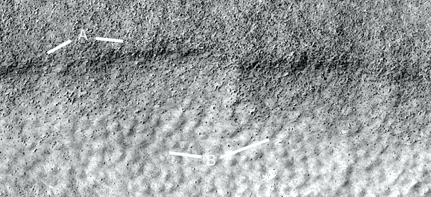
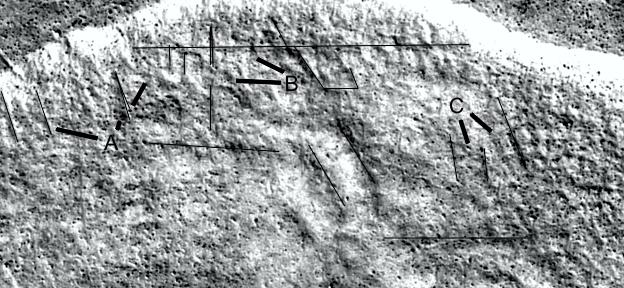
Another segment of the road and more tiles, A shows the edge of the road here is in better condition. As B shows these tiles are mostly transverse, they go from one side of the road to the other approximately at right angles to the direction of the road. They are also about the same size and shape, like cobblestones at B at 2 o’clock.
Prhh1817
Hypothesis
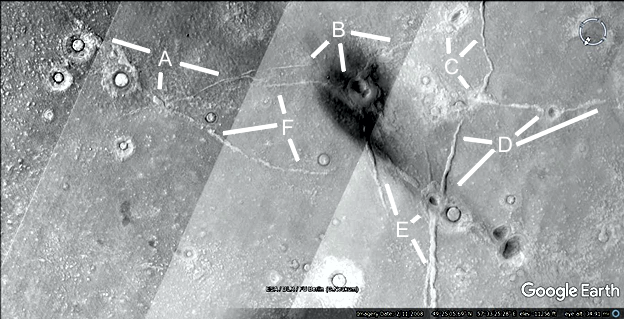
Many more roads are shown here, the other side of the hollow hill in the previous images. A shows a road crossing another at 2 o’clock, B shows many roads between collapsed hills. C shows a road at 4 o’clock going into a rougher area as if the ground is degrading from a maintained state. D shows another straight road, E shows a road going into a hollow hill at 1 o’clock. F shows a road from H going to the edge of a hollow hill. G shows a road at 2 o’clock going through the rougher terrain, this implies the road has not eroded even though this terrain has. It may then be the road is made of stronger material more resistant to erosion.
Prhh1817a
Hypothesis
The lines show how straight the roads are, often not exactly straight. However many medieval roads were not this straight either.
Prhh1818
Hypothesis
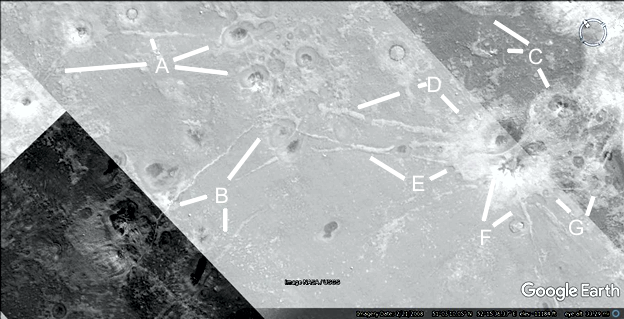
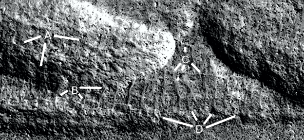
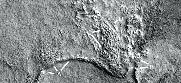
A shows a road coming out of the hill at 10 and 12 o’clock, another road more eroded at 4 o’clock. B shows two roads, one going into a hollow hill at 4 o’clock. C shows two road intersections, one bordering a hollow hill at 1 o’clock, and another with a smaller hill at 4 o’clock. D shows a road going into a hill from a fork at 5 to 4 o’clock. E shows a road connecting to the edge of a hollow hill at 8 o’clock.
Prhh1818a
Hypothesis
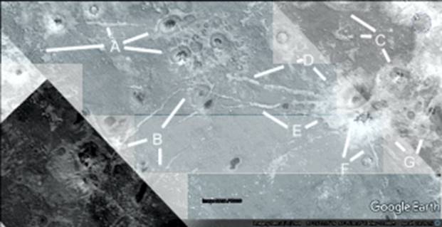
The lines show how straight the roads are.
Prhh1819
Hypothesis
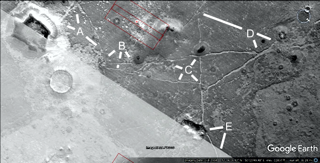
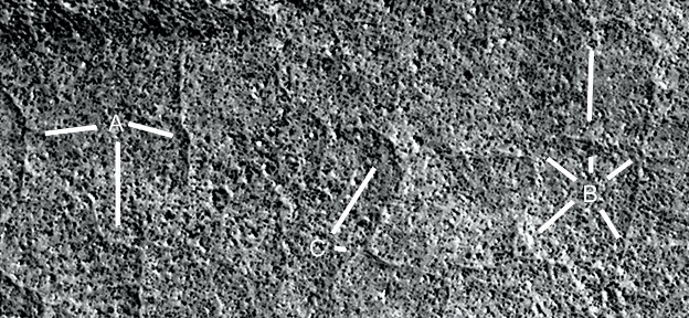
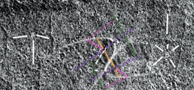
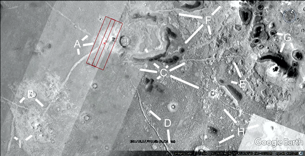
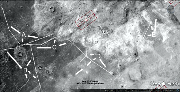
A shows more roads going into two hills and a crater, B shows these roads continuing down to another hill at 7 o’clock and across to 5 o’clock. C shows this road continuing to D at 5 o’clock and another hollow hill. E shows another road. The rectangle around C has more closeups of the road.
Prhh1819a
Hypothesis
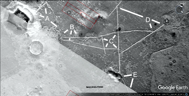
The hollow hill at A has a patch on the roof at 7 o’clock, at 3 o’clock the road may have gone into the hill like a tube. B shows this road continuing on.
Prhh1819b
Hypothesis
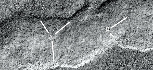
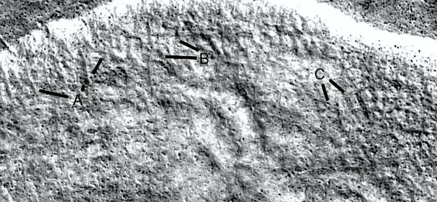
A shows the edge of this road, B shows more of these tiles or cobblestones like Prhh1816d. They are again about the same size and shape. Between A and B the soil from the road side has been blowing onto the road obscuring these cobblestones.
Prhh1820
Hypothesis
A shows a road going into the hollow hill complex at 2 and 4 o’clock, B shows a road from the collapsed hollow hill at 8 o’clock going up to these hills. C shows more hollow hills connecting more by this pale soil as if it is one large habitat. D and E show more roads, F and G other parts of the hills.
Prhh1820a
Hypothesis
Parts of the image have been adjusted in brightness and contrast.
Prhh1821
Hypothesis
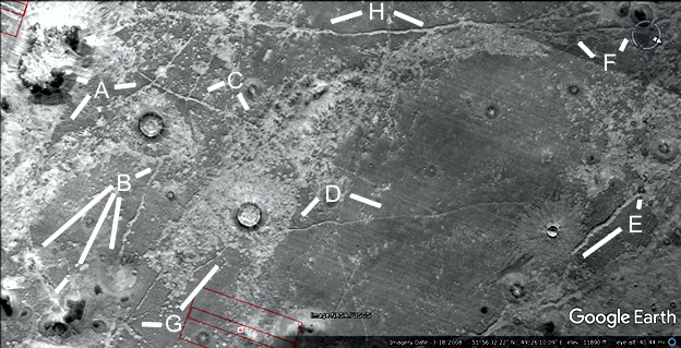
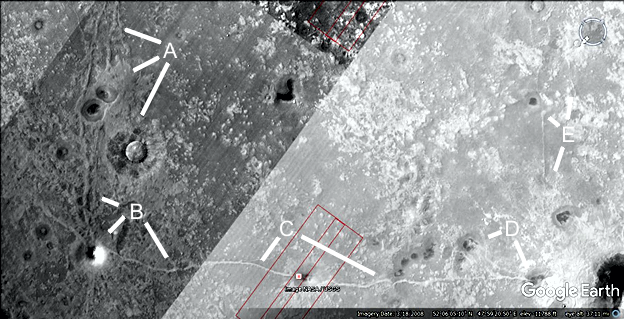
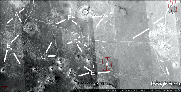
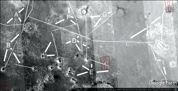
A shows more roads, they connect to a crater at 5 o’clock. B shows a road at 6 o’clock going into a small hollow hill, another at 4 o’clock going into a hollow hill. C shows a road connecting to a complex of hollow hills. D and E show many more roads connecting to hollow hills. F and G show roads connecting to the large crater. H shows a major intersection going up the image.
Prhh1821aa
Hypothesis
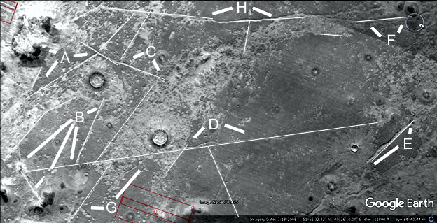
The lines show the roads are generally very straight.
Prhh1821a
Hypothesis
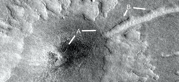
This shows a closeup of road material, it appears to have flaked off at A at 4 o’clock with a large segment at 8 o’clock extending into the side of the road. B shows the side of the road, C shows the road is covered by some material, perhaps this was the state of the intact road before this erosion. D shows a segment that has broken off.
Prhh1821b
Hypothesis
A further closeup of the road shows more possible cobblestones at A at 2 and 9 o’clock. B shows some cavities forming, C may show some larger tiles or plates.
Prhh1821c
Hypothesis
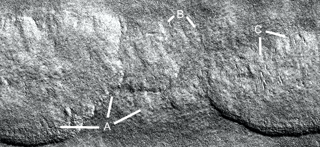
This segment appears to show higher grout between tiles , A shows some rectilinear grout. B shows some clear grout, under this there is another layer of these. C shows a segment at 7 o’clock which continues over the step to the lower level, also one at 4 o’clock. D shows the grout is flusher with the ground at 4 and 9 o’clock, at 2 o’clock there is a step with the grout only on the middle step level. E shows the grout is much higher here, the tiles in between may be highly eroded or settling.
Prhh1821d
Hypothesis
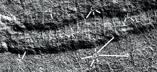
A shows a higher area like a hill, the grout is more visible at 7 and 8 o’clock, at 3 o’clock it is less visible. B shows very rectilinear grout at 4 to 7 o’clock and over to D. At 3 o’clock the grout appears to go into the hill as if the hill is on top of this pattern over to C. The hill to the right of C also appears to sit on top of this grout pattern. D shows another step, the grout does not appear on the lower level.
Prhh1821e
Hypothesis
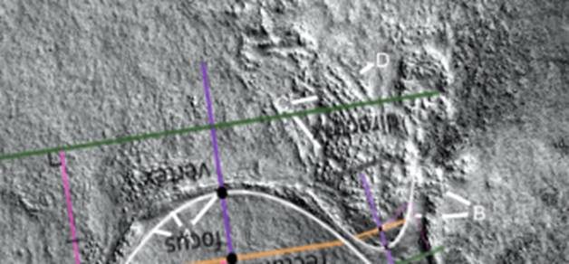
In this segment the grout is less straight, A shows bends in it. They may also be tubes or walls. B shows more rectilinear grout. C shows wavy grout like a double parabola.
Prhh1821e2
Hypothesis
Two connected parabolas are shown.
Prhh1821f
Hypothesis
In this area the grout is also visible, going into the higher terrain at the top of the image. A shows parallel ridges at 10 o’clock, connected like tiles at 1 o’clock second leg. B shows a gap between the grout at 9 o’clock, at to o’clock the horizontal grout extends through much of the image. C shows more of a mesh of grout.
Prhh1821f2
Hypothesis
The lines show how straight the grout is.
Prhh1822
Hypothesis
A shows a road connecting two craters at 10 o’clock, a small hill at an intersection at 6 o’clock, and a fork at 4 o’clock. B shows roads connecting to a hill at 6 o’clock, then over to a hill at 12 o’clock. C shows an intersection at 5 o’clock. D shows a road going to a crater on both sides at 1 and 2 o’clock, another road going down to a hill and crater from 10 to 7 o’clock. E and F show more roads.
Prhh1823
Hypothesis
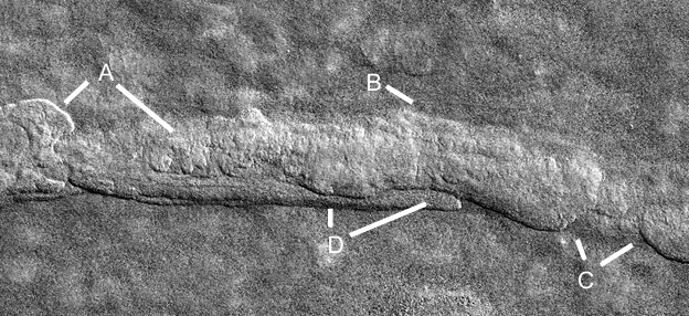
A shows two roads going into a large hollow hill. B and I show roads in an eroded hollow hill complex. C shows two other roads going into this large hollow hill, this might be a good target to be explored for intact rooms. C at 4 o’clock show roads going into a crater. D shows another road, E shows a road going into a large eroded hollow hill complex at G. F and H show more roads.
Prhh1823a
Hypothesis
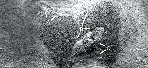
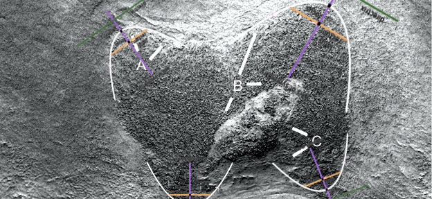
A shows a cavity on the edge of the hollow hill at 11 o’clock extending to 1 o’clock. B shows parallel edges of the pale wall boundary. At 3 and 7 o’clock is the exposed roof, the dark spots on it look like the skin is eroding away. C shows the edge of this pale roof segment, at 8 o’clock the hill has collapsed.
Prhh1823a2
Hypothesis
The hill’s shape can be described by four parabolas, even a fifth between the two top ones.
Prhh1823b
Hypothesis
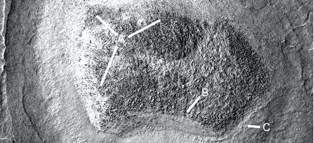
The dark spots again appear to be eroded skin on the roof, A shows these patches and how they define the edge of the roof. B shows a clean edge of this dark material with a smooth pale wall under it like cement. C may be a road or tube.
Prhh1823b2
Hypothesis
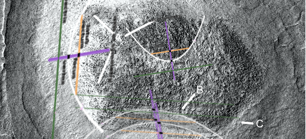
Four parabolas are shown, the two at the bottom and the one on the left are exactly the same parabola.
Hypothesis
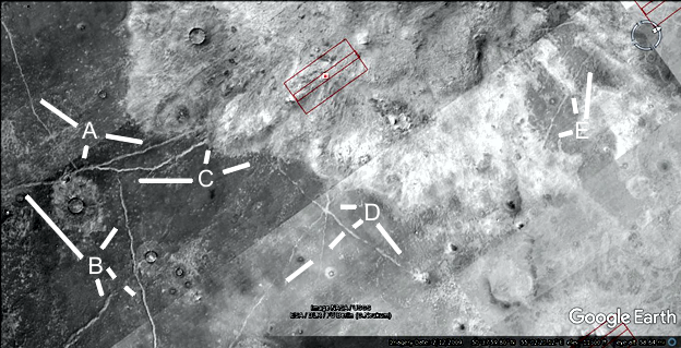
A, B, and C are a complex of roads, this time going into the large pale area which might be a habitat. This again may be a good target for exploration. A at 7 o’clock has a road connecting to a smaller pale area around a crater, perhaps another habitat. D shows a straight road going to a small hill with an intersection at 9 o’clock. E may be collapsed parts of the large hollow hill area.
Prhh1824aa
Hypothesis
The lines show how straight the roads are.
Prhh1824a
Hypothesis
A shows a double wall from 11 to 1 o’clock, this may be a collapsed tube. At 10 o’clock is a break in the tube. B at 9 o’clock second large there are regular pillars or arches as the tube collapses. At 10 o’clock there appears to be a groove down the middle like a tube. C shows parallel walls, this may be a collapsed hill. Many of these are regular in shape and spacing like pillars. D may be an entrance to the hill.
Prhh1824a2
Hypothesis
Two parabolas are shown.