Martian Geometry Book 4
Preface
This preface refers to twelve new books of Martian anomalies. Each book is approximately 250-270 pages in length, they also have the same introduction which is about 70 pages long. There are about ten more books partially completed to be published, the books cover anomalies all over Mars and have about 3000 images in total. If you like these books, and would like to support this work, then you can buy the books on Amazon. You can search for “Greg Orme” and “Martian Hypotheses” there. You can also support this work at Patreon at this link: https://www.patreon.com/ultor. If you enjoy the books you can also help with reviewing them at Amazon.
The aim is to raise money with these books to fund an institute to study these formations. If these are artificial then they will need to be studied by scientists from many fields such as biology (examining the faces, their bodies, and fish sculptures), geology (analysing the materials used in their construction), anthropology (why repeated faces with crowns were constructed, perhaps gods or rulers), mathematics (for geometric formations), sociology (how these societies worked), economists (working out how the society functioned, for example with farming, fishing, working together for large scale constructions), engineering (how these formations were constructed), and archaeology (examining ruins). How this would be done is not clear, but this institute would try to make a start on understanding these formations. No one really knows how to study an extinct alien civilization, if this is one. Most likely, if they are real, then a more professional organization would take over this work later. The intention then is to bridge the gap between amateur analysis of these formation to a much better funded organization, perhaps at the government level. The evidence gives a reasonable case for artificiality, but much study needs to be done to determine how plausible this is.
The introduction is repeated at the start of each book. If you have read it you might skip forward to the new images. However it may be valuable to read it more than once, to see how the images you see are connecting into these classifications. Often the images have a lot of details, each time they are examined more of these can be seen. They might also inspire you to see other connections, for example one image might be similar to another in a different part of Mars. This is likely to happen, even with so many images the surface of this hypothesis is barely being scratched. Mars has an area similar to the land area of Earth, this is because much of Earth is covered in oceans. For this much land then 3000 images is likely to have missed many important discoveries.
You can also use the indexes in each book, they refer to many similar formations throughout them. For example, if you are looking at hypothetical road formations then roads in many different areas can be found in the indexes. It would be possible then to quickly see all the different kinds of hypothetical roads in all 10 books. The idea behind the introduction is to give an outline to the global hypothesis, how these different formations connect together into a hypothetical Martian civilization. It’s important then to get an intuition of how these formations connect together globally.
Some areas for example might have hypothetical roads for transport, other might have hypothetical tubes like a covered road. Different terrain, available materials, and climate might have led to one being used over the other. It may be as Mars cooled it became necessary to travel under cover because of the cold. Another possibility is predators or meteors made traveling on roads too dangerous. Also there are many hypothetical dam formations, but the construction techniques vary between areas. Some are formed with dam walls attached to the crater, when they break some show a cavity under them and others do not. This would indicate the dam wall was dug into this cavity to keep it from sliding down the crater wall. In other areas this was not necessary, it may be that there the crater wall was harder rock which the dam wall could be cemented to. Some show columns and layers in them but others have evenly spaced vertical grooves on the dam walls. Some dams are excavated out of the crater wall or the material at the bottom of the crater, these may depend on the rock type in the crater. For example, if the crater wall is too easily broken then an excavated dam might have been the best engineering solution.
Some areas have hollow hills, these are where a hollow habitat may have been built on an existing hill or the whole hill was constructed. In some areas these have layers similar to a Cobler Dome, this is where bricks form the dome in decreasing circles as the dome is built up. These are called amphitheatres as a friendly name, the first amphitheatre formation looked more like seating around an amphitheatre. Other hypothetical buildings have no layers in their roofs. This may have depended on the materials available. Many appear to have a smooth skin like cement which has broken up in some parts of the roof, and is intact in others. In many areas this is more intact on the southern side, as the skin breaks off the softer inner parts of the roof appear to have eroded faster and collapse. The one sided erosion may imply a prevailing wind, or as the oceans and air froze at the pole this created the erosion.
There are also large areas of walls and room like shapes, these are hypothetical cities. Other areas connect these hollow hills together with tubes or roads as another kind of hypothetical city. Still others seem to be made of tubes that connect together in intersections called a tube nexus. This may have been because of the climate further from the equator, for example tubes might have been used to travel through in colder areas.
The Martian Faces are mainly discussed in books 11 and 12, a reprint of published peer reviewed papers. These differ according to where they are. The Cydonia Face, Nefertiti, and King Face all fall on a great circle, this is hypothesized to have been an old equator that lines up with a known previous pole position west of Hellas Crater. The newly discovered Queen Face is in Cydonia but not near the old equator. If the faces were used to mark latitudes and longitudes then the overall system remains obscure. For example there is a large hyperbola shown close to the old equator. Another is far from this equator, but drawing a line from it to Nefertiti gives a right angle to this old equator. Joining these two hyperbolas and the King Face gives an Isosceles Triangle. The hypothesis of these mapping system is highly speculative at this stage.
Canals, lakes, and water channels also vary in different areas. West of Cydonia there is an extensive array of hypothetical canals, also east and west of Elysium Mons. Some of these connect to larger lakes which may be artificial. Some hypothetical dams have water channels to direct water into a dam, and to collect an overflow to another dam.
There are also darker areas often bounded by walls or geometric shapes. These may have been farms, why they appear in some areas like around Cydonia and in Isidis remains unanswered. Other areas contain hypothetical artefacts but no farm formations, so these creatures would have used a different way of collecting food.
The idea of these books then is not just to prove artificiality, but to try to prove a global hypothesis of how the whole civilization functioned. Once the evidence becomes plausible enough, and the shock wears off, this larger question is much more interesting. Each section is labelled with the title hypothesis to make clear these notions are being proposed along with the evidence there. The sections all have many keywords connecting to the index. If you see a connection to a kind of formation then it is easy to find similar formations. In seeing the global hypothesis the different pieces of the puzzle are more likely to come together, for example the hypothesis of dams sounds less plausible if it is not connected to the hypothesis of buildings and farms. Together they give the ideas of habitation, food, and water. The conclusions can be controversial. However there is so much evidence it was better to put it all together into a more comprehensive hypothesis. Otherwise people are looking at isolated formations like faces without seeing the overall context in which they appear.
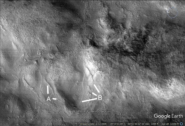
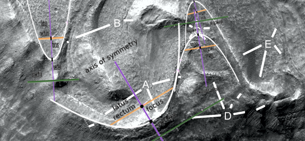
Argd1445a2
Hypothesis
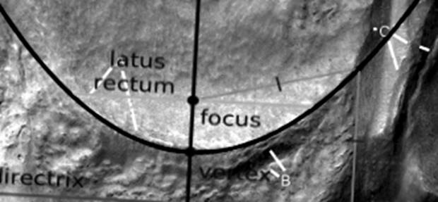
Four parabolic dams are shown, there would be several more if the resolution was better.
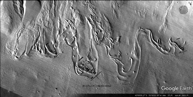
Argd1448
Hypothesis
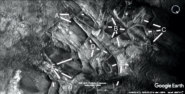
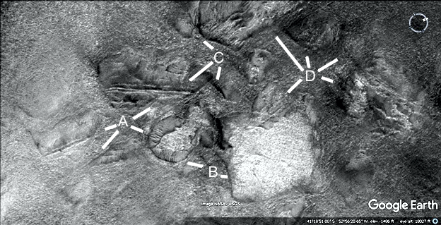
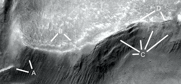
There may be some dams here, A at 11 o’clock looks like a dam as does at 7 o’clock second leg. At 4 o’clock there is a double wall, like an inner and outer parabola. A shows a small dam at 8 o’clock, one at 7 o’clock, and two more at 4 and 5 o’clock. C shows more dams, D and E may be eroded dams.
Argd1448a
Hypothesis
A parabola is shown.
Argd1453
Hypothesis
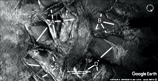
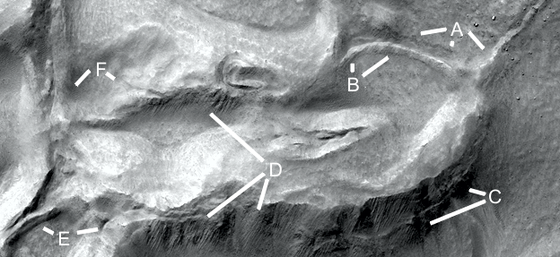
These are similar to the walled fields in Hellas Crater, this is in Argyre Crater so perhaps both have a large lake. A shows some walls, B shows a walled field with the wall from 9 to 11 o’clock having another wall parallel to its left. C may be more walled fields or pit dams. D also might have many segments that would hold water. E at 8 o’clock looks like a small elliptical dam. F shows a large enclosure.
Argd1454
Hypothesis
A at 12 o’clock 3rd leg shows regular grooves in the wall, perhaps pillars as it erodes. At 7 o’clock is a double wall. B shows more of these pillars between 1 and 4 o’clock, also at 5 o’clock. C and D show more walls.
Argd1455
Hypothesis
A shows a parabola, strengthening the evidence of these walls being artificial The enclosure at A at 6 o’clock 3rdleg is also roughly symmetrical. B shows more walls.
Argd1455a
Hypothesis
Two parabolas are shown.
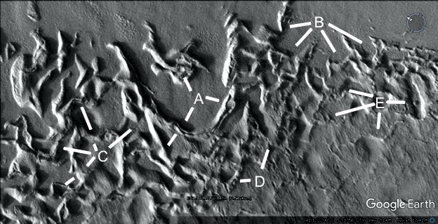
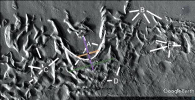
Argd1457
Hypothesis
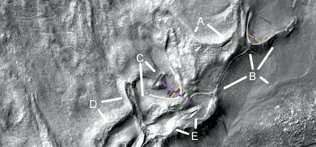
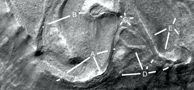
A shows a circular wall at 4 o’clock but this would not be a crater, a straight wall at 7 and another at 8 o’clock. Between A and C is a double wall, at 6 o’clock a right angle. D shows some depressions that can be pit dams or collapsed hollow hills.
Argd1458a
Hypothesis
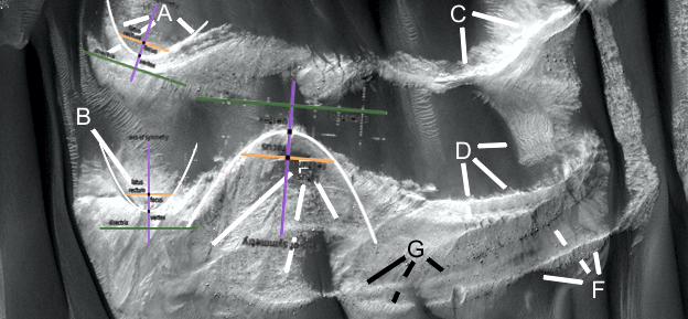
Two parabolas are shown, closeups of parts of this image follow. It appears to show a complex irrigation system. The parabolic dam at B seems to have a pipe coming out of it at 12 o’clock, it also has vertical grooves on the sides at 1 o’clock like pillars. The pipe goes down to 8 o’clock connecting to a second pipe off to its left and down to E. B at 4 o’clock is another pipe. C shows another parabolic dam, D at 2 o’clock is probably a parabolic arch.
Argd1458b
Hypothesis
This shows a closeup of the pipe, at 11 and 1 o’clock it is straight and connects above ground level onto the dam. At B it is more eroded, to the left it connects to a second pipe. They may be regular pillars along the pipe closer to B like supports.
Argd1458c
Hypothesis
A shows some erosion on the dam wall, at 4 o’clock there may be pillars. B shows a flaking off of the cement skin at 11 o’clock, 10 o’clock shows a cavity developing under the dam wall. C would be a water channel and is smooth like cement, at 4 o’clock 2nd leg there is perhaps a second water channel.
Argd1458c1
Hypothesis
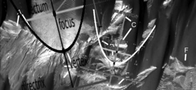
A parabola fits onto this dam except for the right side, many dams have the parabolic shape in the main load bearing segment then curve differently on the sides. This is also an unadjusted parabola, with the standard Y=x2 dimensions, many parabolic dams are narrower than this.
Argd1458d
Hypothesis
This is a closeup of the dam with the pipe connected to it. A shows the top of the pipe may be hollow as if it has collapsed at 10 o’clock, at 11 o’clock there more of these pillars or vertical grooves. They are very evenly spaced without random variations. B may show some erosion as the dam floor cement skin peels off. C shows several layers in the dam wall which appear to be progressively breaking off, D shows more erosion and cracks on the top of the wall.
Argd1458f
Hypothesis
A shows how the pipe at 4 o’clock reaches a junction, a second pipe at 6 o’clock goes off to the left over to B where it may enter a water storage area. There are regular marks along the pipe like supports in it. Between B and F there may be a collapsed part of this storage, another between B and D. C shows more layers breaking off along this formation along with the vertical grooves. D also shows vertical grooves at 6 and 7 o’clock, also at 10 o’clock. E shows an artificial looking segment at 2 o’clock, also a water channel turning into a pipe at 10 o’clock. F shows another dam at 7 o’clock and a pipe or cracks at 4 o’clock.
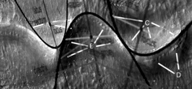
Argd1458j
Hypothesis
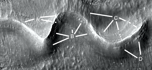
A shows layers in the dam wall at 8 and 5 o’clock, at 2 o’clock there is a double wall on the first leg. The second leg points to a small water channel. B at 3 o’clock may be a small water storage, at 8 o’clock is a water channel. C shows another water channel and perhaps water storage or dam from 4 to 7 o’clock. D shows regular grooves in the wall at 11 o’clock like pillars. At 8 o’clock there may be the end of the water channel, another water channel is at 1 o’clock second leg. 2 o’clock first leg shows a layer, the second leg shows a parabolic dam. E shows another dam at 7 o’clock, the smooth cement wall at 8 o’clock, and an eroded water channel from 1 to 5 o’clock.
Argd1458j2
Hypothesis
Four parabolas are shown, D at 2 o’clock second leg may also be a parabola.
Argd1462a
Hypothesis
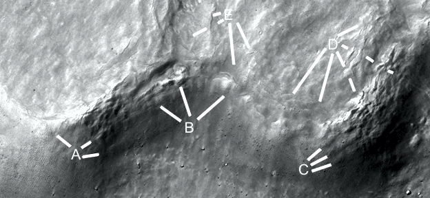
A shows a parabolic dam with dark soil clogging part of it, from 2 to 4 o’clock the walls is highly eroded with dark soil in the cracks. At 7 o’clock the wall is in good condition. B may have been a parabolic dam, between 6 and 8 o’clock the wall appears to have broken. Water may have run here after no repairs were made with 3 flows shown at C. Alternatively these may be 3 small dams and were constructed after the broken dam wall as a repair. D shows another dam.
Argd1462a2
Hypothesis
A parabola is shown.
Argd1462b
Hypothesis
A shows a double parabolic dam, the second wall may be for strength or to catch an overflow. B shows another parabolic dam with a break in the dam wall, water has created a water channel going down from it. This implies the water flowed here after the builders were not here to repair the dam. C also shows a double walled dam. D has a double wall, F at 11 o’clock second leg shows a cavity growing under the wall perhaps leading to its collapse. Above E is a parabolic arch, under it may be an arch as well with a dam at 7 o’clock second leg. F between 12 and 10 o’clock shows vertical grooves perhaps for strength. G may be for supporting the dam above it.
Argd1462b2
Hypothesis
Three parabolas are shown.
Argd1462c
Hypothesis
The dam at A is full of silt, also the dam wall is highly eroded. The vertical grooves in it are more visible. B shows where water has leaved through the dam wall. C at 10 o’clock is probably a buried segment of double wall, at 7 o’clock would be a buried dam. D shows a dam at 6 o’clock and some cracks in the dam wall at 10 o’clock. E and F show other dams.
Argd1462b2
Hypothesis
Two parabolas are shown, E is probably also a parabola.
Argd1467a
Hypothesis
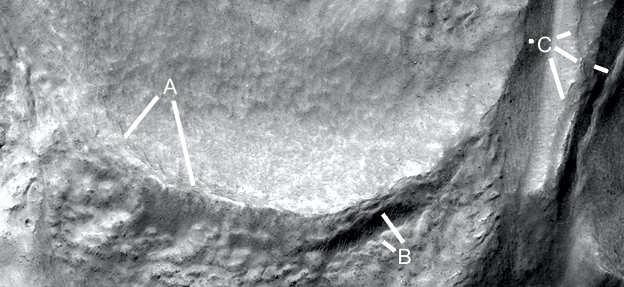
These dams are in better condition with A probably containing more silt. At 8 o’clock the top layer edge of the dam catches the light more, above 8 o’clock there are regular marks like pillars. At 2 and 4 o’clock the dam layers are more eroded, B also shows these at 10 o’clock. At 8 o’clock the vertical grooves may be for strength, also seed at 1 o’clock. The wall is smooth like cement at 12 o’clock, some layers are seen at 2 o’clock. A shows more vertical grooves above the parabolic arch at 10 o’clock, also some layers in the dam floor at 4, 5, and 7 o’clock. D shows more pillars and another layer.
Argd1467a2
Hypothesis
Three parabolas are shown.
Argd1467b
Hypothesis
These dams are more highly eroded, A, B, and C show exposed layers. D and E show layers in the dam floors.
Argd1467b2
Hypothesis
Two parabolas are shown. B is probably a parabolic arch.
Argd1467c
Hypothesis
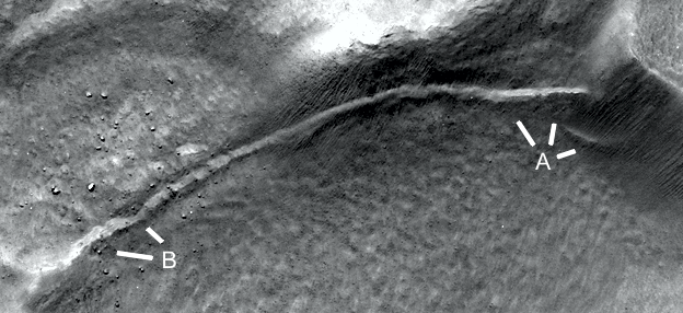
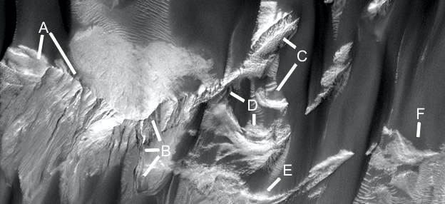
This segment looks like another straight pipe going underground at A at 4 o’clock, this segment may have collapsed giving a U shaped cross section. A shows a layer or pipe from 10 to 2 o’clock, over to B at 8 o’clock The main pipe appears to have a triangular cross section shown at B at 4 and 7 o’clock, C shows another side of it with some vertical grooves or erosion. D shows a water channel at 6 o’clock, also another one at 7 o’clock.
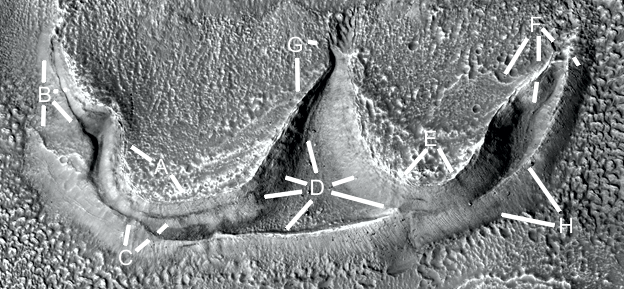
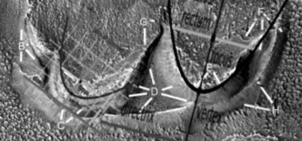
Argd1472a
Hypothesis
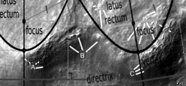
A and E show some erosion on the dam floors, the pale material may also be dried salts. B may show a small dam between 4 and 6 o’clock, it may also be a water channel directing the water to the larger dam under the two main ones. To the right of B at 3 o’clock is a narrow water channel. C at 12 o’clock shows some damage on the top of the dam wall, at 2 o’clock second leg the layer in the dam wall may show the construction technique used. D shows more damage to this dam wall at 9, 10, and 11 o’clock, in this area the dam floor is very smooth like cement. The walls at 2, 4, and 7 o’clock ae in good condition, it may be little water came into the lower dam. F shows the dam floor cement breaking up at 7 o’clock, a water channel at 6 o’clock second leg, and a smooth wall at 5 o’clock second leg. G at 3 o’clock may show a small dam or water channel, at 6 o’clock is the edge of the smooth dam floor in the left dam. H shows a smooth dam wall.
Argd1472a2
Hypothesis
Two parabolas are shown.
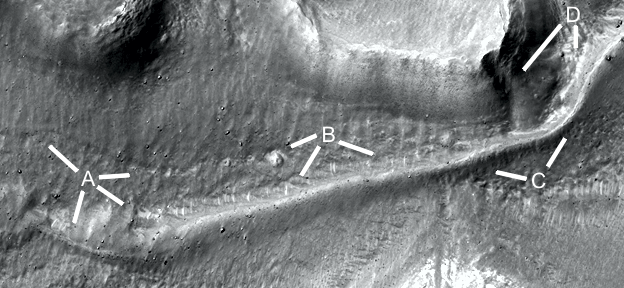
Argd1474
Hypothesis
A and B show the edges of a parabolic dam, A at 12 o’clock is probably a water channel. Bis probably cement in the dam wall breaking up, it can indicate how thick it is.