Martian Geometry 1
Preface
This preface refers to twelve new books of Martian anomalies. Each book is approximately 250-270 pages in length, they also have the same introduction which is about 70 pages long. There are about ten more books partially completed to be published, the books cover anomalies all over Mars and have about 3000 images in total. If you like these books, and would like to support this work, then you can buy the books on Amazon. You can search for “Greg Orme” and “Martian Hypotheses” there. You can also support this work at Patreon at this link: https://www.patreon.com/ultor. If you enjoy the books you can also help with reviewing them at Amazon.
The aim is to raise money with these books to fund an institute to study these formations. If these are artificial then they will need to be studied by scientists from many fields such as biology (examining the faces, their bodies, and fish sculptures), geology (analysing the materials used in their construction), anthropology (why repeated faces with crowns were constructed, perhaps gods or rulers), mathematics (for geometric formations), sociology (how these societies worked), economists (working out how the society functioned, for example with farming, fishing, working together for large scale constructions), engineering (how these formations were constructed), and archaeology (examining ruins). How this would be done is not clear, but this institute would try to make a start on understanding these formations. No one really knows how to study an extinct alien civilization, if this is one. Most likely, if they are real, then a more professional organization would take over this work later. The intention then is to bridge the gap between amateur analysis of these formation to a much better funded organization, perhaps at the government level. The evidence gives a reasonable case for artificiality, but much study needs to be done to determine how plausible this is.
The introduction is repeated at the start of each book. If you have read it you might skip forward to the new images. However it may be valuable to read it more than once, to see how the images you see are connecting into these classifications. Often the images have a lot of details, each time they are examined more of these can be seen. They might also inspire you to see other connections, for example one image might be similar to another in a different part of Mars. This is likely to happen, even with so many images the surface of this hypothesis is barely being scratched. Mars has an area similar to the land area of Earth, this is because much of Earth is covered in oceans. For this much land then 3000 images is likely to have missed many important discoveries.
You can also use the indexes in each book, they refer to many similar formations throughout them. For example, if you are looking at hypothetical road formations then roads in many different areas can be found in the indexes. It would be possible then to quickly see all the different kinds of hypothetical roads in all 10 books. The idea behind the introduction is to give an outline to the global hypothesis, how these different formations connect together into a hypothetical Martian civilization. It’s important then to get an intuition of how these formations connect together globally.
Some areas for example might have hypothetical roads for transport, other might have hypothetical tubes like a covered road. Different terrain, available materials, and climate might have led to one being used over the other. It may be as Mars cooled it became necessary to travel under cover because of the cold. Another possibility is predators or meteors made traveling on roads too dangerous. Also there are many hypothetical dam formations, but the construction techniques vary between areas. Some are formed with dam walls attached to the crater, when they break some show a cavity under them and others do not. This would indicate the dam wall was dug into this cavity to keep it from sliding down the crater wall. In other areas this was not necessary, it may be that there the crater wall was harder rock which the dam wall could be cemented to. Some show columns and layers in them but others have evenly spaced vertical grooves on the dam walls. Some dams are excavated out of the crater wall or the material at the bottom of the crater, these may depend on the rock type in the crater. For example, if the crater wall is too easily broken then an excavated dam might have been the best engineering solution.
Some areas have hollow hills, these are where a hollow habitat may have been built on an existing hill or the whole hill was constructed. In some areas these have layers similar to a Cobler Dome, this is where bricks form the dome in decreasing circles as the dome is built up. These are called amphitheatres as a friendly name, the first amphitheatre formation looked more like seating around an amphitheatre. Other hypothetical buildings have no layers in their roofs. This may have depended on the materials available. Many appear to have a smooth skin like cement which has broken up in some parts of the roof, and is intact in others. In many areas this is more intact on the southern side, as the skin breaks off the softer inner parts of the roof appear to have eroded faster and collapse. The one sided erosion may imply a prevailing wind, or as the oceans and air froze at the pole this created the erosion.
There are also large areas of walls and room like shapes, these are hypothetical cities. Other areas connect these hollow hills together with tubes or roads as another kind of hypothetical city. Still others seem to be made of tubes that connect together in intersections called a tube nexus. This may have been because of the climate further from the equator, for example tubes might have been used to travel through in colder areas.
The Martian Faces are mainly discussed in books 11 and 12, a reprint of published peer reviewed papers. These differ according to where they are. The Cydonia Face, Nefertiti, and King Face all fall on a great circle, this is hypothesized to have been an old equator that lines up with a known previous pole position west of Hellas Crater. The newly discovered Queen Face is in Cydonia but not near the old equator. If the faces were used to mark latitudes and longitudes then the overall system remains obscure. For example there is a large hyperbola shown close to the old equator. Another is far from this equator, but drawing a line from it to Nefertiti gives a right angle to this old equator. Joining these two hyperbolas and the King Face gives an Isosceles Triangle. The hypothesis of these mapping system is highly speculative at this stage.
Canals, lakes, and water channels also vary in different areas. West of Cydonia there is an extensive array of hypothetical canals, also east and west of Elysium Mons. Some of these connect to larger lakes which may be artificial. Some hypothetical dams have water channels to direct water into a dam, and to collect an overflow to another dam.
There are also darker areas often bounded by walls or geometric shapes. These may have been farms, why they appear in some areas like around Cydonia and in Isidis remains unanswered. Other areas contain hypothetical artefacts but no farm formations, so these creatures would have used a different way of collecting food.
The idea of these books then is not just to prove artificiality, but to try to prove a global hypothesis of how the whole civilization functioned. Once the evidence becomes plausible enough, and the shock wears off, this larger question is much more interesting. Each section is labelled with the title hypothesis to make clear these notions are being proposed along with the evidence there. The sections all have many keywords connecting to the index. If you see a connection to a kind of formation then it is easy to find similar formations. In seeing the global hypothesis the different pieces of the puzzle are more likely to come together, for example the hypothesis of dams sounds less plausible if it is not connected to the hypothesis of buildings and farms. Together they give the ideas of habitation, food, and water. The conclusions can be controversial. However there is so much evidence it was better to put it all together into a more comprehensive hypothesis. Otherwise people are looking at isolated formations like faces without seeing the overall context in which they appear.
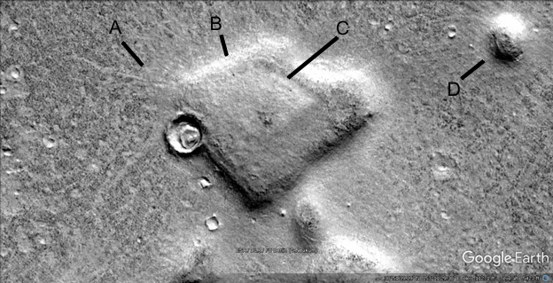
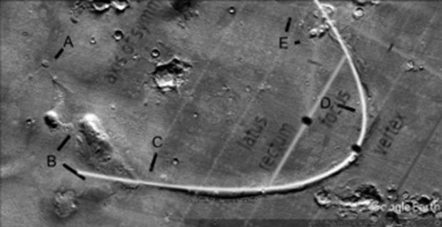
Ht5
Hypothesis
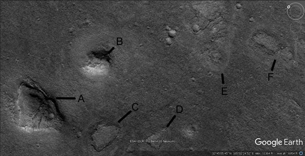
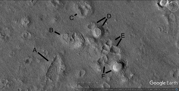
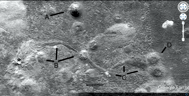
This long ridge may be a tube, it connects into many craters here along A and B. Some of the hills are also unusual, they may be hollow hills. Mathematicians might consider how a parabola would be formed efficiently on such a large scale, engineers on how a long hollow structure could be created. Sociologists might consider how these craters would have been used, to get water for possible farming, drinking, raising fish, etc. Biologists can regard this as a clue to the ecosystem, that water may have come from a water table, from rain, etc.
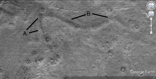
Ht5a
Hypothesis
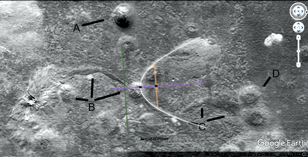
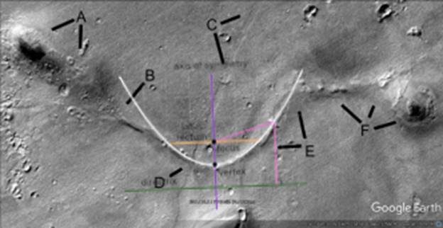
This shows how part of the formation is close to a perfect parabola, the right curve at B is also close to a parabola. Mathematicians might investigate the other parts of this formation, whether there is a way to create them on a large scale like this.
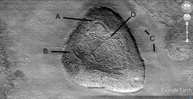
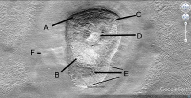
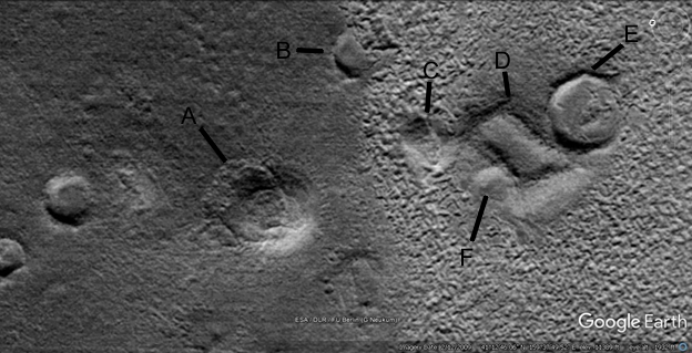
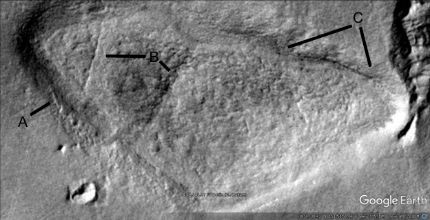
Hhh12
Hypothesis
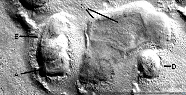
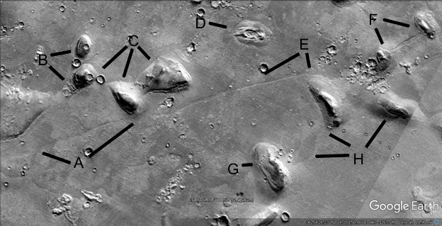
This hill shows clearer signs of patching, A indicates a darker external wall and a center that has either settled or is designed this way. In between there is a groove that is even in depth and width rather than randomly changing. This may have occurred by design or from the center settling. B shows a lip running around the edge of this interior hollow, it is also even in size and width. C shows a cleared area around the hill as if the material was used from here, or it was maintained to be cleaner. For example it may have been used for crops. Horticulturalists might consider whether some cleared areas could have been used for crops. D shows a ridge like part of an interior support.
Hhh14
Hypothesis
This hill also appears to have been altered. A shows a wall on the upper side which is fairly regular. B shows a pale section which make have lost an outer skin, accounting for the change in shade. It may also be a patch. C may be an area that is settling, there appears to be tubes on the surface which may be a lip around a patch. The area is quite chaotic as it if had been patched many times. D shows another patch like shape like a parallelogram. It has a pale groove going off it to the left all the way to the edge of the hill. E shows a dark area at 9 o’clock, at 8 and 10 o’clock there is a step between the higher outer area and this section. The step at 10 o’clock appears to continue to the left to the line from B. This lines between the shades give the impression of patches or a deliberate design. This also has a cleared area around it, another possibility is dust storms might threaten to bury some hills and so the ground around them was cleared regularly.
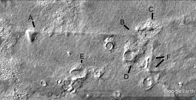
Hhh18
Hypothesis
A shows a line narrow pale area, it may be a patch or a collapsed cavity. B is a similar stripe. C shows an irregular dark shape above the pale material, it is however only around the hills not further out. So a sandstorm could not do this without covering the area above A,B, and C. D shows 4 more possible patches, E is all dark on one side and F shows another long cavity. G shows a dark hill above the same kind of pale material, this would not have eroded from the hills because they are not big enough.
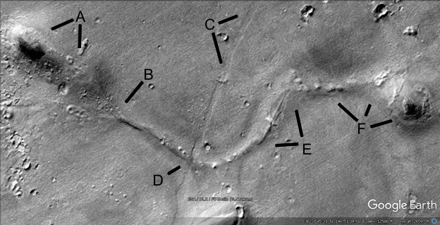
Hhh19
Hypothesis
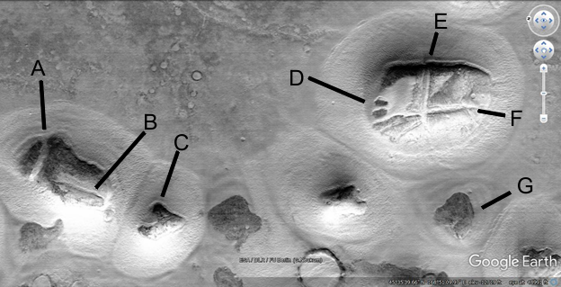
This shows possible roads leading between hollow hills, it is logical that there would be movement between them. Sociologists and perhaps anthropologists may examine these routes to understand their use. It might for example be trade on the longer roads, movement to and from crops, etc. Some hills may be more important as communal meeting places, have government functions, house animals, be markets, etc. A shows something has worn the surface down to paler material, it looks like many lanes of a freeway. It may then indicate a lot of traffic, forming separate roads to avoid congestion. B shows a larger road shape going into smaller ones, it may also be the space between the roads has eroded making it look larger. E shows a hollow hill that has collapsed, there is a pale track from the roads at A and C to it. Roads appear in many routes to the right, a larger one at D. C shows a more separate road, it may be crops were planted in this direction.
Already the components of a possible civilization are starting to emerge. There are tubes connecting craters for water, hollow hills for dwellings, and roads between them. These represent a priori predictions, with more images the concepts of a civilization should be repeated to be real.
Hp26d
Hypothesis
This hill shows signs of decay on its roof on the second section of A at 5 o’clock. B shows a possible tube going up the side of the hill and inside it. Some appear to end at the edge of hills at ground level, others seem to enter further up. A at 4 and 7 o’clock appear to show another tube.
Hp50
Hypothesis
A shows a hollow hill with cracks or bands of darker material along its roof, perhaps in the process of collapse into a pit like C. It as a crater on the roof which may have caused the cracks. B shows possible patches on its roof and perhaps has collapsed on the left side. There is a lighter area from A to around B, perhaps caused by traffic. D is another pit, to its right is probably another collapsed hollow hill. E may be a very large hollow hill with some interior supports showing, only the lower part appears to have some elevation. F appears to have an interior support pointed at by the F line.
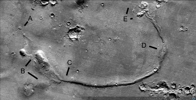
Hp51
Hypothesis
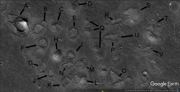
Many pits, probably former hollow hills are shown. A has a large interior support still standing but the rest seems to have fallen into pits. C and F have some structure remaining, H appears to be largely standing with a patch or cavity on its roof. It may be some shapes lasted longer, like a more conventional rounded dome here. When the shape becomes too elongated it may have points of weakness where it will crack first, bringing down the rest. L is more rounded and has survived, as well as parts of O. Engineers could consider how to model this terrain, then construct dome shapes on these pits. This may give insights into which would have been more stable. There are few interior supports here which may have caused the problems, however these may well have collapsed after the atmosphere had frozen.
Hp52
Hypothesis
So many hollow hills have collapsed here, it is on the eastern edge of the Hecates area nearer the ancient ocean. A tsunami from a meteor impact may have caused this. B and C show interior supports, A may have faint signs of one. E seems to have 4 interior supports but still collapsed, with no debris it may have been washed away. H and I may have had an interior support, J up to 6. Sociologists might consider why some hollow hills were much bigger than others, whether this was for the creatures to gather in or because some were wealthier. Often there are very large hills with settled sections on the roofs, then there are smaller hills around them.
Hp53
Hypothesis
Many more pits here, to the left of the A line there appears to be an entrance. B and C are somewhat heart shaped which is a recurring motif with these pits. H shows an intact hollow hill that seems to reach out and join to a crater, called a hilled crater here. This may have been to use the water in the hill, perhaps there were tunnels directly into the side of the crater. It is also problematic for geologists, a crater is supposed to impact randomly. This hill could not have known to be exactly in this position, as if it is catching a ball in a mitt. Also the crater is flattened on the hill side like it has been rebuilt there.
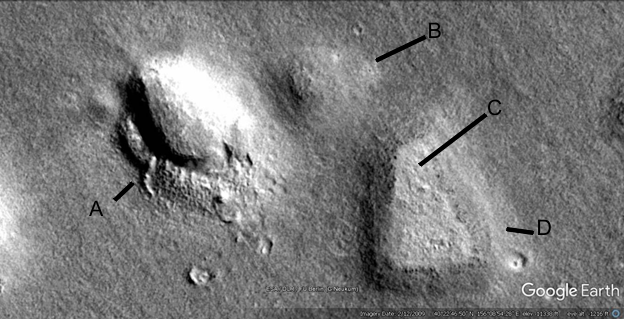
Hp57
Hypothesis
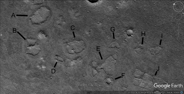
A has a sharper point than most pits, the narrow pale area may have been an entrance. C is also built up more on the lower side. Some of the pale mounds in this area might be small habitats.
Hp65
Hypothesis
A has a straight edge on its left side, the right side of it seems to be full of material perhaps from the collapsed roof. C has much thicker walls so this is more of a cavity than a pit. D shows a walled hill on the lower side and a pit above it. F shows a pit with a tube going into the walled hill, also called a tubed hill here, it has a similar flat roof to D. It may have been part of E as one large hill.
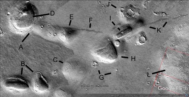
Hp68
Hypothesis
A appears to show the interior supports sticking through the settled roof, as if ready to collapse. D looks like a very artificial pit with straight walls, though it may have had a dome for a roof, it also seems to be connected to C. There also seems to be a connection to the crater E. The mottled surface is also seen in many areas, it appears in some cases like many corridors are going through it. This may have been a construction technique to make much wider habitats by using many more interior supports.
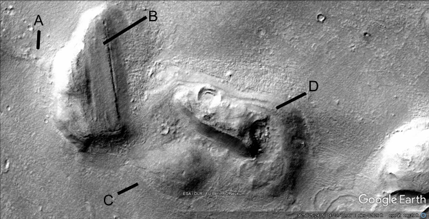
Hhh87a
Hypothesis
This shape would appear to be natural, but it closely follows a parabola as in many other areas.
Hhh87a2
Hypothesis
Here is a parabola superimposed on the ravine around this hill.
Ht89
Hypothesis
A shows a small hill with cracks and perhaps a patch on its roof. B shows a tube going from the crater on the left to the collapsed hill in the middle. Then it continues on to C with a pale spot at 10 o’clock like a collapsed hollow hill. At 12 o’clock and 2 o’clock C shows a tube like shape that expands to two other collapsed hills at D. The whole area under B and C may be a large low hollow hill, there is a mottled appearance perhaps from collapses.
Ht89a
Hypothesis
A parabola is shown.
Hhh97
Hypothesis
A and B show a thick wall that extends upwards to the next hill, partially like a tube. A also points at a settled cavity on the roof surface. There is a mottled skin here exposing a smooth core as in Hhh95, perhaps the same construction technique. There may have been a smooth skin like cement over this that was peeled off. C shows a walled hill with the concave roof perhaps settled. D shows a smaller hollow hill perhaps patched.
Hhh98
Hypothesis
A is a walled hill with a concave roof, this also has bands of darker material. The crater there does not appear to have collapsed it. B shows this is connected to C by a tubed hill, in this case tubes come out of both sides to connect the outermost hills. C has possible patches on its roof and skin on its left which may have originally covered the hill. D shows a larger tube going down to a crater, this merges with many smaller tubed ravines. They can be seen by their lighter left side like with the hills showing they are not ravines. E shows a possible tube on the side of the hilled crater F at 11 o’clock. At 9 o’clock the hill may have a cavity or a large crater on its roof. G shows a peeled skin on the hill. Hi, I, and J show a tubed hill connected to a tubed pit. H is very angular and artificial looking.
Hhh99
Hypothesis
A shows a mottled appearance perhaps a collapsed section. B shows a hollow hill fading down perhaps to a pad rather than a pit. C and D show a walled hill.
Hhht104
Hypothesis
A is a tubed hill connected by a tube to B, also to a decayed hollow hill at C. It also connects to a decayed hilled crater at D The tube at F connects to another crater, E also appears to be a tubed crater with the tube coming out of it down the image.
Hhht106
Hypothesis
A shows how this tube like hill connects to the hill at D. This also connects to E and to a road at F going through the dark hill I to the road at K. I has 2 lines, the first shows a road or tube coming out of J and the second line further on is a darker hill road with the road K coming out of it. D has a collapsed section on the left, perhaps some patches on its roof. E appears to have settled on the peak of its roof with some cracks, similar to a pingo. H looks like a hollow hill with the skin peeled off except for its left side. The connection to D is smooth like cement though very ancient, other materials appear to have collapsed or disappeared. J appears to have missing ejecta perhaps to build the other hills. B has a skin on the upper side on both hills, the left hill has a cavity probably as the hill collapses. C is probably a collapsed hill, there may be another one between D and E. G shows a road or tube between a small hill and a crater. L may be a large hollow hill.
Hhht128
Hypothesis
A appears to be a tube, B is an unusual hill with a straight flat section of roof. C appears to have cavity shapes on its lower side and perhaps a dark patch on its upper side. D has many cavity shapes as well, the crater may have collapsed part of the hill. Under where the line comes from D there may be another crater that caused a collapse, there is a circular arc to the cavity here. The right side of the crater appears to be missing so perhaps it was repaired.
Hhht129
Hypothesis
A shows a small hill with a tube or road going down to the left, and perhaps a pad where a hill was. It goes down to the right through another small hill, then a large hill then to B at 2 o’clock. B at 4 o’clock shows a wide tube going to a collapsed hill to its left. C s a long tube perhaps connected to two craters on its way to a collapsed section at D. E shows many tubes like a mesh around small hills with a cavity on their roofs.
Hhht129a
Hypothesis
A parabola is shown.
Hhht130
A shows a partially collapsed hill, a tube comes out of it at B where it crosses a groove at D. This may have been a small river that cut the tube, it appears unlikely because there are no signs of pooling on one side before it broke through. It may also be a collapsed tube or road shown by C. The tube goes to the right through E where it appears to have collapsed, this may also be an interior support of a former hill. F shows a series of small hills on a tube leading to a partially collapsed hill on the right with a dark patch on its roof.
Hhht130a
Hypothesis
A parabola is shown.
Hhht132
Hypothesis
A appears to be a groove like a collapsed tube, it goes to a hill at E. B shows two hills with craters on their roofs. These have not collapsed the hills or they were repaired to act as dams. C at 8 o’clock shows a crater connected to one of the hills, C at 4 and 7 o’clock shows two partially collapsed hills. D shows another collapsed hill. F shows two hills connected be an extension of this groove, showing it cannot be a river. G shows a partially collapsed hill, at 9 and 10 o’clock there is a dark area connecting the two hills. H at 2 o’clock shows another partially collapsed hill.
Hhht134
Hypothesis
A shows a walled hill with a concave roof, there are the interior supports showing through at B perhaps as the roof settled. C shows a section of the wall that is steep, with a lip on the lower side down to the roof. Such a roof might itself have been a dam to collect water, even to grow crops on it.
Hhht139
Hypothesis
A shows a road going into the walled hill, the pale concave roof looks very unnatural at C. The walls as shown at B are very steep, the crater on the left again appears molded into the hill with more roads coming out of it to the left. D connects to the walled hill with roads, it also has some settled areas on its roof.