Martian Hypotheses Book 8
Preface
This preface refers to twelve new books of Martian anomalies. Each book is approximately 250-270 pages in length, they also have the same introduction which is about 70 pages long. There are about ten more books partially completed to be published, the books cover anomalies all over Mars and have about 3000 images in total. If you like these books, and would like to support this work, then you can buy the books on Amazon. You can search for “Greg Orme” and “Martian Hypotheses” there. You can also support this work at Patreon at this link: https://www.patreon.com/ultor. If you enjoy the books you can also help with reviewing them at Amazon.
The aim is to raise money with these books to fund an institute to study these formations. If these are artificial then they will need to be studied by scientists from many fields such as biology (examining the faces, their bodies, and fish sculptures), geology (analysing the materials used in their construction), anthropology (why repeated faces with crowns were constructed, perhaps gods or rulers), mathematics (for geometric formations), sociology (how these societies worked), economists (working out how the society functioned, for example with farming, fishing, working together for large scale constructions), engineering (how these formations were constructed), and archaeology (examining ruins). How this would be done is not clear, but this institute would try to make a start on understanding these formations. No one really knows how to study an extinct alien civilization, if this is one. Most likely, if they are real, then a more professional organization would take over this work later. The intention then is to bridge the gap between amateur analysis of these formation to a much better funded organization, perhaps at the government level. The evidence gives a reasonable case for artificiality, but much study needs to be done to determine how plausible this is.
The introduction is repeated at the start of each book. If you have read it you might skip forward to the new images. However it may be valuable to read it more than once, to see how the images you see are connecting into these classifications. Often the images have a lot of details, each time they are examined more of these can be seen. They might also inspire you to see other connections, for example one image might be similar to another in a different part of Mars. This is likely to happen, even with so many images the surface of this hypothesis is barely being scratched. Mars has an area similar to the land area of Earth, this is because much of Earth is covered in oceans. For this much land then 3000 images is likely to have missed many important discoveries.
You can also use the indexes in each book, they refer to many similar formations throughout them. For example, if you are looking at hypothetical road formations then roads in many different areas can be found in the indexes. It would be possible then to quickly see all the different kinds of hypothetical roads in all 10 books. The idea behind the introduction is to give an outline to the global hypothesis, how these different formations connect together into a hypothetical Martian civilization. It’s important then to get an intuition of how these formations connect together globally.
Some areas for example might have hypothetical roads for transport, other might have hypothetical tubes like a covered road. Different terrain, available materials, and climate might have led to one being used over the other. It may be as Mars cooled it became necessary to travel under cover because of the cold. Another possibility is predators or meteors made traveling on roads too dangerous. Also there are many hypothetical dam formations, but the construction techniques vary between areas. Some are formed with dam walls attached to the crater, when they break some show a cavity under them and others do not. This would indicate the dam wall was dug into this cavity to keep it from sliding down the crater wall. In other areas this was not necessary, it may be that there the crater wall was harder rock which the dam wall could be cemented to. Some show columns and layers in them but others have evenly spaced vertical grooves on the dam walls. Some dams are excavated out of the crater wall or the material at the bottom of the crater, these may depend on the rock type in the crater. For example, if the crater wall is too easily broken then an excavated dam might have been the best engineering solution.
Some areas have hollow hills, these are where a hollow habitat may have been built on an existing hill or the whole hill was constructed. In some areas these have layers similar to a Cobler Dome, this is where bricks form the dome in decreasing circles as the dome is built up. These are called amphitheatres as a friendly name, the first amphitheatre formation looked more like seating around an amphitheatre. Other hypothetical buildings have no layers in their roofs. This may have depended on the materials available. Many appear to have a smooth skin like cement which has broken up in some parts of the roof, and is intact in others. In many areas this is more intact on the southern side, as the skin breaks off the softer inner parts of the roof appear to have eroded faster and collapse. The one sided erosion may imply a prevailing wind, or as the oceans and air froze at the pole this created the erosion.
There are also large areas of walls and room like shapes, these are hypothetical cities. Other areas connect these hollow hills together with tubes or roads as another kind of hypothetical city. Still others seem to be made of tubes that connect together in intersections called a tube nexus. This may have been because of the climate further from the equator, for example tubes might have been used to travel through in colder areas.
The Martian Faces are mainly discussed in books 11 and 12, a reprint of published peer reviewed papers. These differ according to where they are. The Cydonia Face, Nefertiti, and King Face all fall on a great circle, this is hypothesized to have been an old equator that lines up with a known previous pole position west of Hellas Crater. The newly discovered Queen Face is in Cydonia but not near the old equator. If the faces were used to mark latitudes and longitudes then the overall system remains obscure. For example there is a large hyperbola shown close to the old equator. Another is far from this equator, but drawing a line from it to Nefertiti gives a right angle to this old equator. Joining these two hyperbolas and the King Face gives an Isosceles Triangle. The hypothesis of these mapping system is highly speculative at this stage.
Canals, lakes, and water channels also vary in different areas. West of Cydonia there is an extensive array of hypothetical canals, also east and west of Elysium Mons. Some of these connect to larger lakes which may be artificial. Some hypothetical dams have water channels to direct water into a dam, and to collect an overflow to another dam.
There are also darker areas often bounded by walls or geometric shapes. These may have been farms, why they appear in some areas like around Cydonia and in Isidis remains unanswered. Other areas contain hypothetical artefacts but no farm formations, so these creatures would have used a different way of collecting food.
The idea of these books then is not just to prove artificiality, but to try to prove a global hypothesis of how the whole civilization functioned. Once the evidence becomes plausible enough, and the shock wears off, this larger question is much more interesting. Each section is labelled with the title hypothesis to make clear these notions are being proposed along with the evidence there. The sections all have many keywords connecting to the index. If you see a connection to a kind of formation then it is easy to find similar formations. In seeing the global hypothesis the different pieces of the puzzle are more likely to come together, for example the hypothesis of dams sounds less plausible if it is not connected to the hypothesis of buildings and farms. Together they give the ideas of habitation, food, and water. The conclusions can be controversial. However there is so much evidence it was better to put it all together into a more comprehensive hypothesis. Otherwise people are looking at isolated formations like faces without seeing the overall context in which they appear.
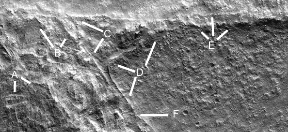
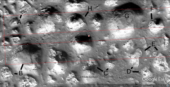
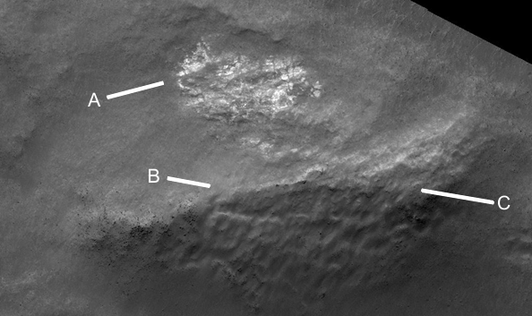
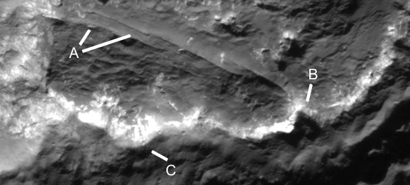
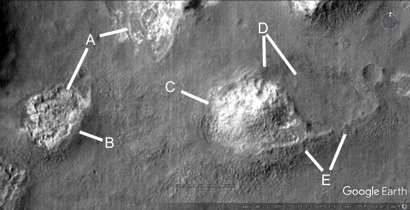
Cymd201
A shows some cavity shapes which may have collected water. B shows another dam, approximately parabolic.

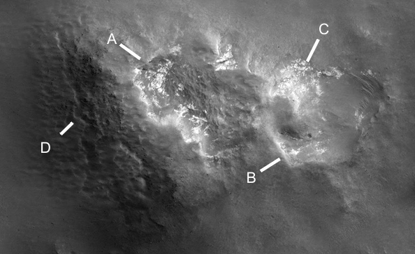
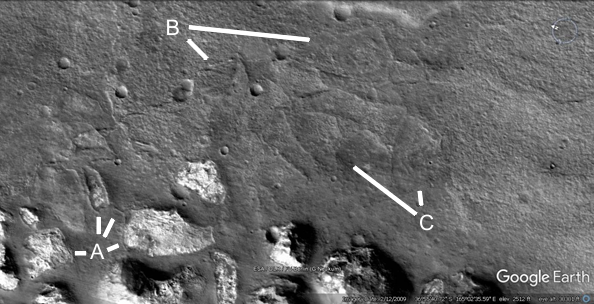
Cymhh202
This shows many hollow hills in stages of collapse, A is approximately symmetric perhaps also using this crater as a dam. C also seems to use a crater, it is unlikely an impact would not break the side of the rim even as the hill collapsed into a pit. There is also missing ejecta, perhaps used to build the hills. D is more intact but has collapsed on the right side, E is collapsed to the point of being flat ground. F goes further to collapse to a pit, the pale material should be the same as that for the rooms and ceilings.
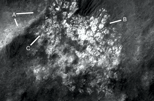
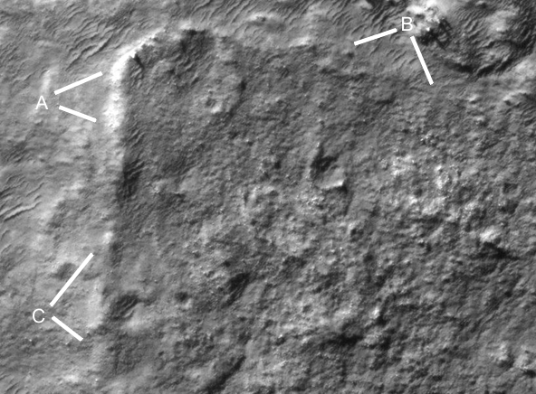
Cymhh202a
In this HiRise image of Cymhh202 A shows the pit edge, B confirms this pale material is forming walls and rooms. C shows a ridge which may be an interior support. D shows how the pit edge turns to join the interior support ridge.
Cymhh202b
This shape is unnatural, approximately like an eye. A shows the pit edge appears to have a skin broken off like the hill collapsed leaving it up in the air. This was also seen in many collapsed hollow hills in Hecates. B shows a narrow groove like an entrance. C shows the bottom of this hill, still sharp like some dam walls. D shows how this pale material is attached to the ridge like some rooms are.
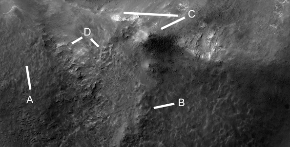
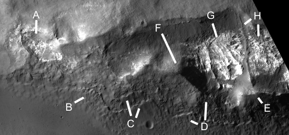
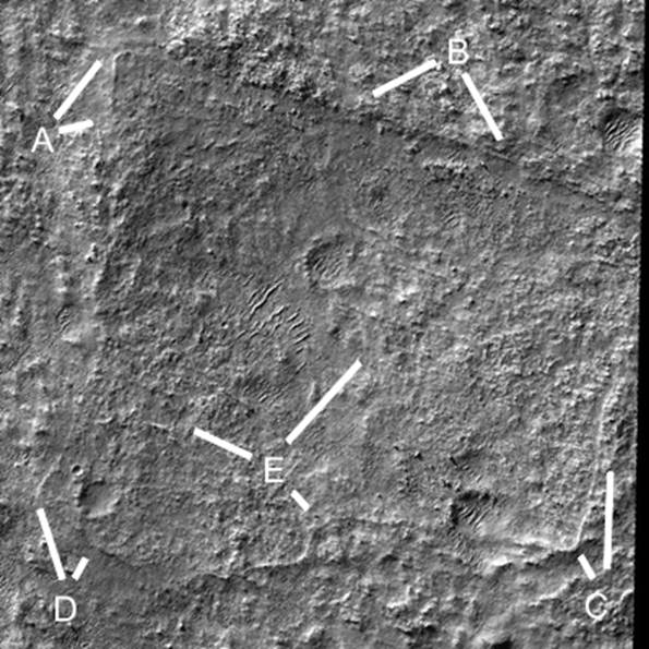
Cymhh203
This shows another HiRise image, A is a collapsed hill. B shows a collapsed hill at 9 o’clock and one collapsed on the edges at 1 o’clock. C shows two more collapsed hills as does D. E shows many collapsed hills. F shows a hill more intact on the upper side and collapsed on the lower side, G is more complete. H shows a partially collapsed hill on the lower side at 7 o’clock.
Cymhh203a
A shows an internal ridge. B shows cracks in the pale material like the floor is breaking up. If there were walls here they have eroded away perhaps leaving dark cracks in the floor. C shows a less eroded area like rooms, it appears to vary in height.
Cymhh203b
There is an impression here from the shadows of three dimensional room shapes. A shows a wall at 2 o’clock, at 10 and 12 o’clock there appears to be a squarish shape under the pale material. This may have collapsed as higher rooms eroded covering these in part. B looks to be two long narrow rooms at approximately 45 degrees from horizontal. E also looks like three long narrow rooms. C is like a recess in the rock, D may be two more long narrow rooms. It seems unlikely to be an optical illusion as the light and dark areas are consistent with shadows.
Cymhh203c
These walls are more like a tetrahedron than cubes, A shows bare walls and a nexus of walls partially covered by ceiling material. B also shows a nexus of walls with hollows around it. Six walls appear to come together at C. D shows a triangle of walls with one bisecting the base. E shows a corner of two walls with a hollow inside, between D and F it is like a rectangular shallow box suspended by some walls.

Cymhh203c2
This shows the possible squarish shape suspended by other walls.
Cymhh203c3
This shows how straight some of the other walls are.

Cymhh203d
This shows the pale material eroding away to nothing, forming an empty pit. B and C show part of the wall still standing.
Cymhh203e
Another hill having collapsed, the pale material would be more walls and rooms. A shows where the hill has collapsed. Bis a squarish shape also collapsed with pale material inside. C shows more pale material. D shows a crack in the intact wall perhaps from the strain of the other parts having collapsed.
Cymhh203f
A shows an intact part of the hill, B the edge where it collapsed. C shows a peak of the hill at 8 o’clock and a collapsed area at 9 o’clock. D shows two room areas, at 4 o’clock there are several intact rooms. At 8 o’clock there are walls.
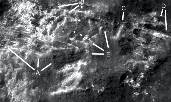
Cymhh203g
A shows an interior support and T junction, probably a right angle. B shows a wall in good condition yet the hill above it has collapsed, C shows another wall. D at 4 and 10 o’clock shows another wall. D at 8 o’clock shows another wall coming from a T junction. E shows more walls, there are pale squarish shapes like the eroding floors of rooms on the edges of the pit.
Cymhh203g2
The lines show how straight parts of the formation are.
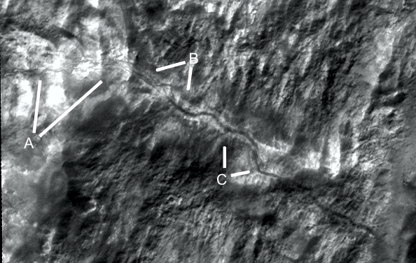
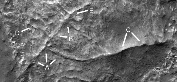
Cymhh203h
A may be a crack. B and C shows a meandering line like a road or tunnel through the hill. It is unlikely to be a crack because of its even width as if it is open the whole way. Also cracks tend not to meander.
Cymhh203i
This looks like a floor that is eroding, the dark lines might be where walls had fitted into the floor. C shows a pit with no floor material, D shows the edge of the floor with these dark lines.
Cymhh203j
A shows more walls and room shapes, B, C and E show the pale edges of this material. D shows the intact part of the hill.
Cymhh203k
A and B show the edges of this collapsed area, under this the hill appears intact. C looks like a crack or it has broken a layer here. D shows where this ceiling material is eroding. E F and G show more erosion of this.
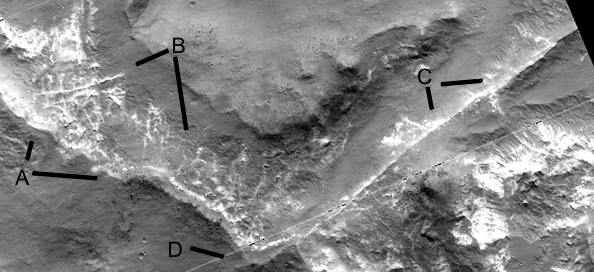
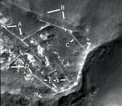
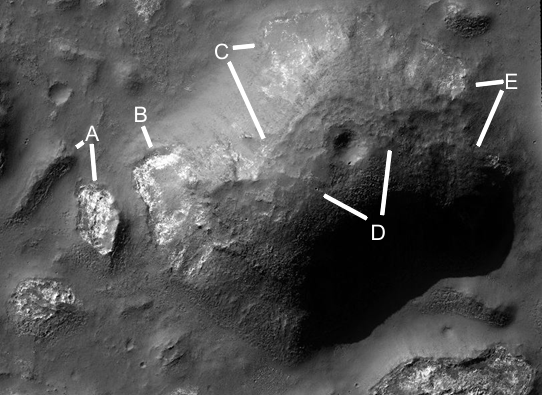
Cymhh204
A and B show more hills collapsed, C is less eroded but perhaps collapsed in the middle. D at 2 o’clock shows a pit on the side of a crater, this is hard to explain as it looks like the pit came after the crater. It encroaches over the round shape of it. If the hills are so fragile they can collapse by themselves, then an impact should have collapsed all of it, but one corner remains standing. E shows a collapsed hill at 10 o’clock and an intact hill at 6 o’clock.
Cymhh204a
This shows either tubes or internal supports from a hill, it has a different shape with more right angles to other internal supports. A appears to show collapsed parts of the tubes. B has a groove along it like a collapsed tube. D has 5 parallel tubes running off this, they may end or go to other habitats underground. C is likely to be another tube.
Cymhh204b
A shows how the internal support, B connects to it. C appears to be eroded walls. E is the edge of the collapsed hill. D may be a tube or internal support as with F and G.
Cymhhw204c
A shows an internal support, B and C show how the collapsed edge has pale materials on the inside.
Cymhh204d
A shows some wall shapes in a cavity, B shows some layers which seem to have broken off. The layers then may have protected the roof of the hollow hill, when this skin decayed the softer material under this collapsed. This is similar to the hollow hills when they collapsed in Hecates. C also shows these broken layers. D shows the layer at 10 o’clock and a collapsed cavity is at 12 o’clock. E shows the edge of the hill and how it connects to this interior support, at H at 8 o’clock, that goes all the way over to the other side of the hill. F shows possibly the peak of the former hill, G and H at 6 o’clock shows pale material that may have been rooms.
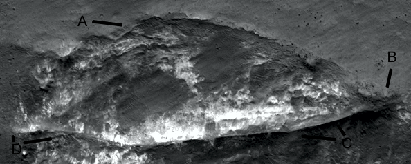
Cymhh204e
A at 6 o’clock show a hill that has collapsed, at 8 o’clock another shows no signs of collapse. The layers shown may be the key to this, as the skin peeled off the hill began to collapse. B shows an area of the large hill that forms a cavity, the pale material in close ups is usually rooms. Some may not be, for example there may be a pale layer of material in the ground that is used in walls but in some hills may be undisturbed. C shows an edge at 5 o’clock and a possible collapse at 3 o’clock. D may show settled areas, the crater may also have been repaired around it. E shows another collapsed area and possible settled parts of the roof. Engineers may be able to calculate from modeling these hills how they might collapse, and what that implies about interior supports in them. These usually seem to be too low to hold up the roof, they may then be like domes with no real support under them. The interior supports might hold the hill from spreading which could cause the roof to flex.
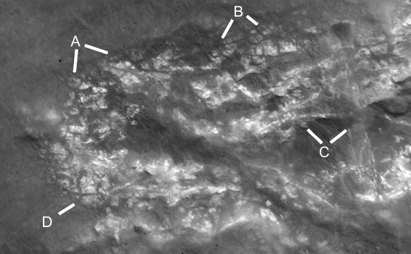
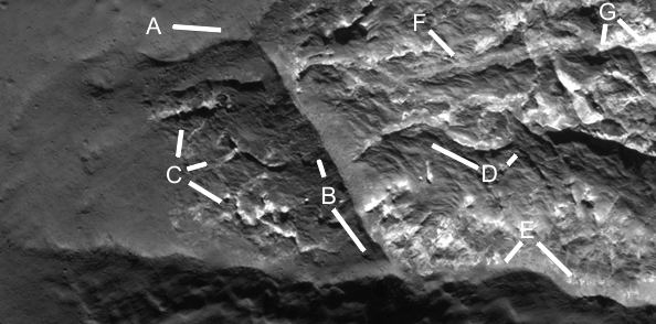
Cymhh204g
More examples of how these walls form rooms, A shows a T junction going down to E at 10 o’clock. Other walls appear to crisscross each other, this may to give internal support to stop the hill edges from flexing. E at 2 o’clock shows a wall with a flat surface and apparent railings, this could have been used like a road so these upturned edges prevented the creatures from falling off. These are very faint, however many of these ridges like roads have these higher edges like former walls. D shows how these extend to the edge of the hill, perhaps to connect to external tubes and roads. C to F may have been a room if these walls were higher. B shows a collapsed area with a wall inside it.
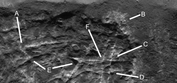
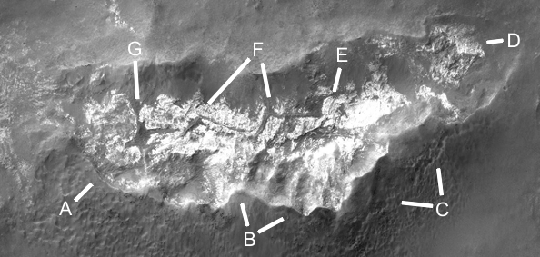
Cymhh205
A at 7 o’clock and B shows a collapsed hill with much more of this pale material, it may be this was multiple floors of rooms. A at 2 o’clock shows more wall shapes as if this hill is much more eroded. C is another example, the pale material may have lost its dark outer skin and have quickly collapsed on the right side. This large pit at D at 4 o’clock and E at 1 o’clock has no signs of pale material and may have been completely hollow. If so then there were no interior supports helping to hold up the roof, this is also found in the Hecates area though most have some internal supports. These also were often low and would not have reached up to the roof.
Cymhh206
A shows a pit at 12 o’clock connected with a tube to the more intact hill at 2 o’clock. At 9 o’clock there is another collapsed hill. B and C show many imprints like collapsed hills except there is only a shallow pit. These may have filled in over time from dust storms, the roof material could have filled them up, or some did not have a pit under them perhaps because the ground was harder to excavate. Engineers might be able to estimate how much material was in these roofs and how much of a pit would be filled by it.
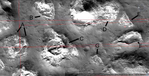
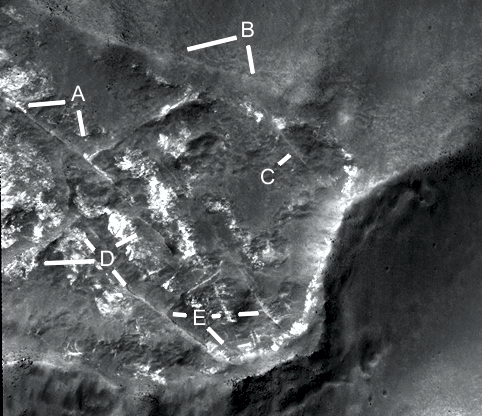
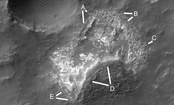
Cymhh209a
A, B, C, and D show the faint edges of a pit. A and C have sharp edges as if made of stronger material more resistant to erosion. The inside of the pit is also much smoother with no large rocks like outside. This would be a likely outcome if the area had been cleared as a construction technique for the hill, some rocks might come up from underground over time but not as many as outside this. There is a faint impression of some walls and rooms laid out on this, it may also be a cement pad highly eroded and covered in the same soil as outside it. E shows a curved wall at 4 o’clock, there may have been a rectangular room at 10 o’clock, and another at 2 o’clock. If large enough a cleared area like this might be a good landing spot for a rover to explore the area.
Cymhh209b
This is a closeup of the previous upper left corner, there is a definite impression of a wall going from A to C and some parts appear to be higher like a cement pad. B also appears higher, the texture of the ground is also different to outside this. If this is cement then rocks would not come from underground, but some might form as the cement broke up.
Cymhh209c
This is a closeup of the curved wall mentioned earlier, A show this wall is broken at 4 o’clock. B and C show a curve which is close to two parabolas. D shows this part of the wall is breaking up on the right into separate rocks.

Cymdhh209c2
This shows two parabolas superimposed on the curved wall, the latis rectums are approximately parallel and form a rectangle as they join to the apex of each other. This would be a simple way to build a curved wall so the two curves line up with each other.
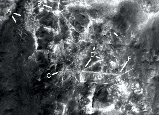
Cymhh209d
Here the wall is also well preserved, A at 9 o’clock may have been a small hill. Between the B lines appears to be a break in the wall. C may show three walled areas. D shows a continuation of a possibly collapsed tube with a hollow inside as 12 o’clock, this extends from C at 2 o’clock. D at 5 and 7 o’clock may also show smaller walls at right angles to the main wall pointing downwards.

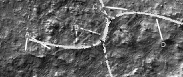
Cymhh209e
A may show small rooms with walls, some have right angles. B at 11 o’clock shows a flat area like a room, at 1 o’clock there is another wall. C shows a curved wall at 10 o’clock and a straight wall at 7 o’clock. D shows a smoothly curved corner leading to a straight wall at 7 o’clock, F shows a fork into two walls. E shows an inner and outer wall here with a hollow in between like a road with railings.