Martian Hypotheses Book 7
Preface
This preface refers to twelve new books of Martian anomalies. Each book is approximately 250-270 pages in length, they also have the same introduction which is about 70 pages long. There are about ten more books partially completed to be published, the books cover anomalies all over Mars and have about 3000 images in total. If you like these books, and would like to support this work, then you can buy the books on Amazon. You can search for “Greg Orme” and “Martian Hypotheses” there. You can also support this work at Patreon at this link: https://www.patreon.com/ultor. If you enjoy the books you can also help with reviewing them at Amazon.
The aim is to raise money with these books to fund an institute to study these formations. If these are artificial then they will need to be studied by scientists from many fields such as biology (examining the faces, their bodies, and fish sculptures), geology (analysing the materials used in their construction), anthropology (why repeated faces with crowns were constructed, perhaps gods or rulers), mathematics (for geometric formations), sociology (how these societies worked), economists (working out how the society functioned, for example with farming, fishing, working together for large scale constructions), engineering (how these formations were constructed), and archaeology (examining ruins). How this would be done is not clear, but this institute would try to make a start on understanding these formations. No one really knows how to study an extinct alien civilization, if this is one. Most likely, if they are real, then a more professional organization would take over this work later. The intention then is to bridge the gap between amateur analysis of these formation to a much better funded organization, perhaps at the government level. The evidence gives a reasonable case for artificiality, but much study needs to be done to determine how plausible this is.
The introduction is repeated at the start of each book. If you have read it you might skip forward to the new images. However it may be valuable to read it more than once, to see how the images you see are connecting into these classifications. Often the images have a lot of details, each time they are examined more of these can be seen. They might also inspire you to see other connections, for example one image might be similar to another in a different part of Mars. This is likely to happen, even with so many images the surface of this hypothesis is barely being scratched. Mars has an area similar to the land area of Earth, this is because much of Earth is covered in oceans. For this much land then 3000 images is likely to have missed many important discoveries.
You can also use the indexes in each book, they refer to many similar formations throughout them. For example, if you are looking at hypothetical road formations then roads in many different areas can be found in the indexes. It would be possible then to quickly see all the different kinds of hypothetical roads in all 10 books. The idea behind the introduction is to give an outline to the global hypothesis, how these different formations connect together into a hypothetical Martian civilization. It’s important then to get an intuition of how these formations connect together globally.
Some areas for example might have hypothetical roads for transport, other might have hypothetical tubes like a covered road. Different terrain, available materials, and climate might have led to one being used over the other. It may be as Mars cooled it became necessary to travel under cover because of the cold. Another possibility is predators or meteors made traveling on roads too dangerous. Also there are many hypothetical dam formations, but the construction techniques vary between areas. Some are formed with dam walls attached to the crater, when they break some show a cavity under them and others do not. This would indicate the dam wall was dug into this cavity to keep it from sliding down the crater wall. In other areas this was not necessary, it may be that there the crater wall was harder rock which the dam wall could be cemented to. Some show columns and layers in them but others have evenly spaced vertical grooves on the dam walls. Some dams are excavated out of the crater wall or the material at the bottom of the crater, these may depend on the rock type in the crater. For example, if the crater wall is too easily broken then an excavated dam might have been the best engineering solution.
Some areas have hollow hills, these are where a hollow habitat may have been built on an existing hill or the whole hill was constructed. In some areas these have layers similar to a Cobler Dome, this is where bricks form the dome in decreasing circles as the dome is built up. These are called amphitheatres as a friendly name, the first amphitheatre formation looked more like seating around an amphitheatre. Other hypothetical buildings have no layers in their roofs. This may have depended on the materials available. Many appear to have a smooth skin like cement which has broken up in some parts of the roof, and is intact in others. In many areas this is more intact on the southern side, as the skin breaks off the softer inner parts of the roof appear to have eroded faster and collapse. The one sided erosion may imply a prevailing wind, or as the oceans and air froze at the pole this created the erosion.
There are also large areas of walls and room like shapes, these are hypothetical cities. Other areas connect these hollow hills together with tubes or roads as another kind of hypothetical city. Still others seem to be made of tubes that connect together in intersections called a tube nexus. This may have been because of the climate further from the equator, for example tubes might have been used to travel through in colder areas.
The Martian Faces are mainly discussed in books 11 and 12, a reprint of published peer reviewed papers. These differ according to where they are. The Cydonia Face, Nefertiti, and King Face all fall on a great circle, this is hypothesized to have been an old equator that lines up with a known previous pole position west of Hellas Crater. The newly discovered Queen Face is in Cydonia but not near the old equator. If the faces were used to mark latitudes and longitudes then the overall system remains obscure. For example there is a large hyperbola shown close to the old equator. Another is far from this equator, but drawing a line from it to Nefertiti gives a right angle to this old equator. Joining these two hyperbolas and the King Face gives an Isosceles Triangle. The hypothesis of these mapping system is highly speculative at this stage.
Canals, lakes, and water channels also vary in different areas. West of Cydonia there is an extensive array of hypothetical canals, also east and west of Elysium Mons. Some of these connect to larger lakes which may be artificial. Some hypothetical dams have water channels to direct water into a dam, and to collect an overflow to another dam.
There are also darker areas often bounded by walls or geometric shapes. These may have been farms, why they appear in some areas like around Cydonia and in Isidis remains unanswered. Other areas contain hypothetical artefacts but no farm formations, so these creatures would have used a different way of collecting food.
The idea of these books then is not just to prove artificiality, but to try to prove a global hypothesis of how the whole civilization functioned. Once the evidence becomes plausible enough, and the shock wears off, this larger question is much more interesting. Each section is labelled with the title hypothesis to make clear these notions are being proposed along with the evidence there. The sections all have many keywords connecting to the index. If you see a connection to a kind of formation then it is easy to find similar formations. In seeing the global hypothesis the different pieces of the puzzle are more likely to come together, for example the hypothesis of dams sounds less plausible if it is not connected to the hypothesis of buildings and farms. Together they give the ideas of habitation, food, and water. The conclusions can be controversial. However there is so much evidence it was better to put it all together into a more comprehensive hypothesis. Otherwise people are looking at isolated formations like faces without seeing the overall context in which they appear.
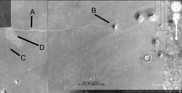
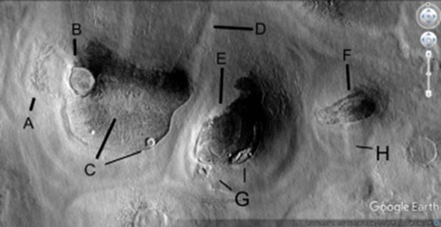
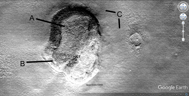
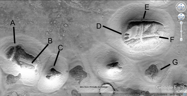
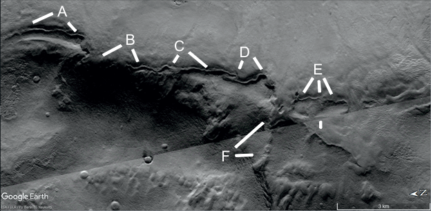
Hc2
Hypothesis
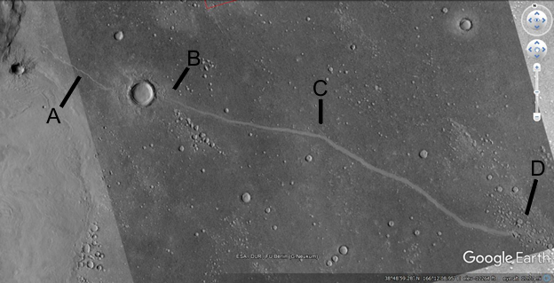
A shows a long hill with a banded roof, consistent with the hollow hills. B and D show some unusual formations, they look like the larger formation at C. However C is supposed to be a crater with an ejecta pattern but B and D are not. It implies the hypothesis that they are all formed the same way. This will be referred to as tubed ejecta. The pale spots may have been hollow hills, they appear in many other areas. Engineers could consider how these hollow hills could be built, also how the material in ejecta could be reformed like this. For example how large these structures could be without collapses, and what materials would have been available. Geologists could evaluate the amount of ejecta here for such a small crater in the middle of C, how this could be possible. Sociologists could consider how a community like this would function, with large buildings the creatures would have to live together rather than in separate small dwellings. This implies a highly communal species. Archeologists might consider how these possible ruins have degraded compared to known human formations on Earth.
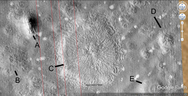
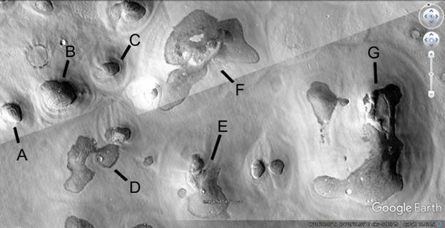
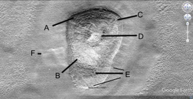
Hc2a
Hypothesis
These also relate to the pale spots, they look more like hollow hill formations. A appears to have degraded on the lower right leaving an imprint at 7 o’clock. The 4 o’clock formation at A appears to have a hollow center culminating with B at 7 o’clock. The B formation at 5 o’clock looks more like a rounded hill but is the same material as the other unusual shapes. The others at 2 and 4 o’clock with B have the same hollow center but more artificial external shapes. Engineers and geologists might look at where this pale material came from, and how it may have been transported. The hollow areas give an indication of how thick the walls needed to be to support a cavity this large. Planetary scientists might consider whether this was to protect against meteor impacts, whether they had to be strong enough to withstand these. Some of these hills have impact craters on them that appear to have been repaired, they can be used to estimate how strong the hills were.
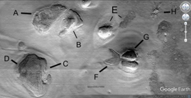
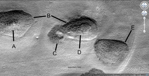
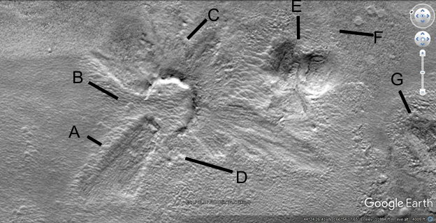
Hc3
Hypothesis
The formation at A appears to be coming out of the crater but it cannot be ejecta. There are no other materials like this coming out, ejecta should be even around a crater or at least not in one direction. A is also symmetrical. Geologists might try to match this material up, to explain why it appears to be so different to the ejecta. B is similar to the tube crater material, instead of being even the ejecta is evenly spaced into ejecta fingers of material. Engineers might try to model this as a large building, fingers of constructed dwellings formed from taking the material on the sides leaving the finger shapes. At 8 o’clock C shows a pit like shape, at 6 o’clock a tube or road going into a pale spot. There are many pits like this next to hollow hills, engineers might work out where the material went as the hills collapsed. It might have to be fine enough to blow away, or it might fill the pits.
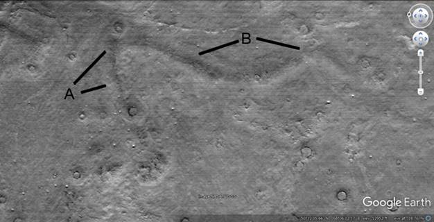
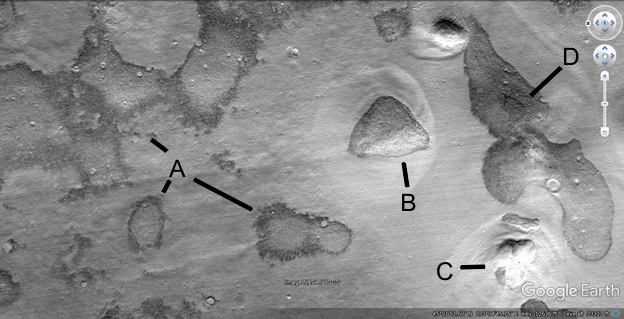
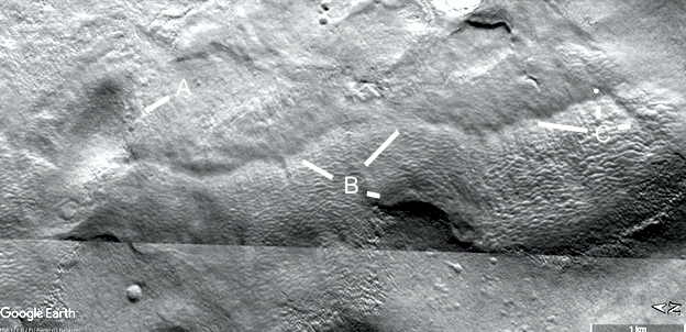
Ht5
Hypothesis
This long ridge may be a tube, it connects into many craters here along A and B. Some of the hills are also unusual, they may be hollow hills. Mathematicians might consider how a parabola would be formed efficiently on such a large scale, engineers on how a long hollow structure could be created. Sociologists might consider how these craters would have been used, to get water for possible farming, drinking, raising fish, etc. Biologists can regard this as a clue to the ecosystem, that water may have come from a water table, from rain, etc.
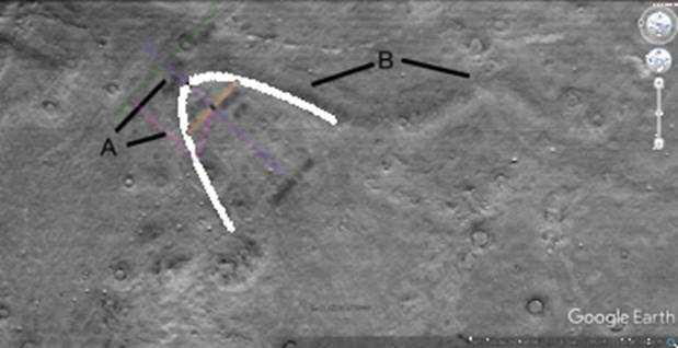
Ht5a
Hypothesis
This shows how part of the formation is close to a perfect parabola, the right curve at B is also close to a parabola. Mathematicians might investigate the other parts of this formation, whether there is a way to create them on a large scale like this.
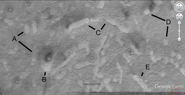
Ht6
Hypothesis
This area has many pale spots, the ones at 2 o’clock in A are long rather than a round shape like a mud volcano. Geologists might compare these to mud volcanoes and how they could form naturally being so long like this. Some may be natural and others modified from mud volcanoes or take materials from them. B shows a hill of similar material but with a dark roof center like many hollow hills, perhaps a patch from a damaged area such as from a meteor impact. Engineers might consider how a hill like this might be patched if hit by a meteor. C shows a line of the pale spots in an arc, similar to a parabola but too short to tell exactly. D shows two more pale spots, the one at 10 o’clock seems to have dark material like seeps coming out of it. E shows one formation with some structure inside it, perhaps as it eroded the interior supports are showing. Some appear much more eroded almost to nothing while others have structure in them. Engineers might compare this to other hollow hill structures, about how they seem to be able to decay into pits or just imprints on the ground.
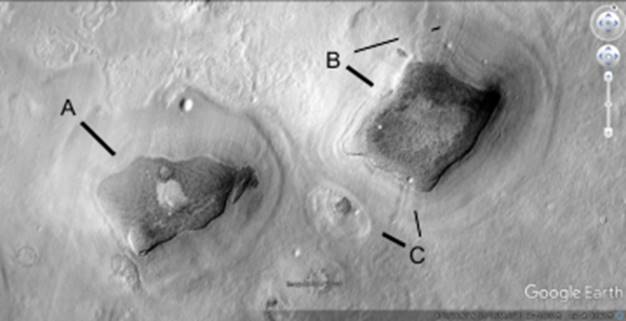
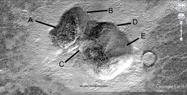
Hhh7
Hypothesis
These two formations may be hollow hills, the dark roof material may be from being patched. Both have a center that is of lighter shade. B is hollower in the center, it might use a more rounded interior support like a catenary. B shows at 2 o’clock lines going into the formation, perhaps entrances. C at 10 o’clock may show a hollow hill that has collapsed into a pit, just part of the dark roof remaining. At 11 o’clock there may be entrances into the hill. These may indicate the material is partially wind blown or Aeolian, so a track was formed through it by the inhabitants. It may be these were also connected by tunnels, which are exposed in many other images to come. Geologists might consider how these come to be buried equally on all sides, wind usually comes from one direction on Mars and so sand should be heaped up on one side preferentially. Sociologists might consider the question of why so few external right angles are encountered in these possible constructions, though as will be seen many are found internally. This may indicate a primitive knowledge of construction techniques, or a lack of materials able to be built with vertical and horizontal sections.
Hhh8
Hypothesis
A shows part of the hollow hill that may have collapsed into a pit. B shows a crater that may have been patched after the impact, otherwise being on the edge of the hill it should have broken on the left side. It is almost exactly running along the edge but the rim did not break which is unlikely. C shows some decay in the dark roof material. E shows a pale area in the dark roof, perhaps where it is buried or collapsing into a pit. D shows material coming out of a hollow hill, perhaps a tube. F shows a band like shape in the roof material, perhaps from construction. G shows a possible entrance at 10 o’clock, and a possible collapsed area of the hill at 12 o’clock. H may show entrances or a straighter section buried under the sand. All the hills may be partially buried indicating their extreme age or adverse weather events such as sand storms at some stage. For example with a large impact or the atmosphere beginning to freeze, winds may have moved sand burying some formations as in an Earth desert. Climatologists may consider this as indicating a drier climate, perhaps prone to dust storms. Water then may have come mainly from an Artesian basin, perhaps water from the paleosea in Utopia and Elysium Planitias. Geologists might consider how the nearby volcanoes, particularly Hecates Tholus would affect groundwater. For example larger communities appear to be clustering around volcanoes, this one is near Hecates Tholus, another is to the east of Elysium Mons. One is to the west of Olympus Mons and Alba Patera. Another is to the east of Alba Patera. One is to the north of Nili Patera. One is in Argyre Crater with several smaller volcanoes. Another is in Cymmeria with many smaller volcanoes. In Hellas Crater there are several volcanoes, possibly 3 volcanoes in a line on its western side. Each then might affect the climate nearby as well as melt groundwater.
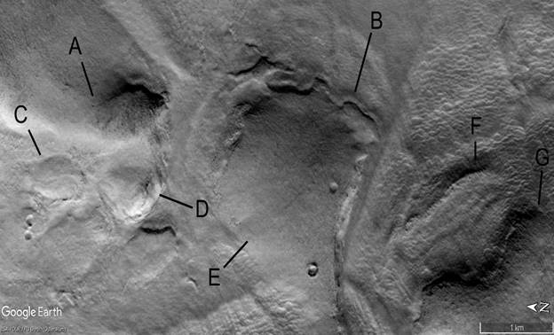
Hhh9
Hypothesis
All these hollow hills may be partially buried, or be using the lighter material around them for construction. The dark material is more than just above the buried areas, it has structure such as in B. A also appears to have near vertical sides rising out of the pale material. D appears more like it is buried with a smaller area above the pale material. E is a combination of the two, some parts seem to rise sharply above the pale material while other areas are more gradual. Like D, F is paler indicating it may be eroding or is covered with some lighter material such as from a sandstorm. It has some smaller dark areas as if from patches. G shows an area that appears to have collapsed indicating that this is a hollow hill.
Hhh10
Hypothesis
Another example of hollow hills, the dark roof material at A seems less likely to be protruding from buried areas. This is because higher areas towards the center remain covered. The center of the hill between A and C appear to rise sharply in the middle. B has a small area of dark roof material, it may be these were deliberately buried to for example insulate from weather changes. D shows a lighter roof with a dark area perhaps a patch. Meteor strikes may have occurred sometimes and the roofs would need to be patched. E may be a hollow hill that collapsed into a pit.

Hhh11
Hypothesis
A shows a hill like in previous images, but apparently having collapsed or eroded. On its bottom edge it appears to be higher, on its upper left the pale areas may have been cavities. The middle seems to have disappeared as well, this may have been another cavity. B may also have been a separate hollow hill, the pale area may also have been a cavity for habitation. C shows another cavity, between C and D there are bands of different shades possibly from a constructed roof. D shows a darker area pointing to a crater. The darker area abuts one side of the crater so closely this may have been a patch. E shows a smaller hill at 7 o’clock with darker areas on its roof, at 4 o’clock a dark area which may be a collapsed hill or the material used on the roofs. F shows a hill with a large piece gone unless it is buried. G shows a hill with dark bands on its roof, H has uneven ejecta as if some had been used in construction.
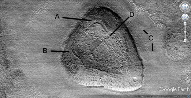
Hhh12
Hypothesis
This hill shows clearer signs of patching, A indicates a darker external wall and a center that has either settled or is designed this way. In between there is a groove that is even in depth and width rather than randomly changing. This may have occurred by design or from the center settling. B shows a lip running around the edge of this interior hollow, it is also even in size and width. C shows a cleared area around the hill as if the material was used from here, or it was maintained to be cleaner. For example it may have been used for crops. Horticulturalists might consider whether some cleared areas could have been used for crops. D shows a ridge like part of an interior support.
Hhh13
Hypothesis
Another hollow hill similar to Hhh12, the darker wall surrounds a lighter center. Others have a darker center and lighter walls, geologists might consider how these could reverse if natural. The center is not rounded, the wall seems to be about the same width all around it on the left. B shows a darker area but it appears to have the same elevation as the lighter area. To the right of this the lighter area may have partially collapsed. C again gives the impression of a cleared area.
Hhh14
Hypothesis
This hill also appears to have been altered. A shows a wall on the upper side which is fairly regular. B shows a pale section which make have lost an outer skin, accounting for the change in shade. It may also be a patch. C may be an area that is settling, there appears to be tubes on the surface which may be a lip around a patch. The area is quite chaotic as it if had been patched many times. D shows another patch like shape like a parallelogram. It has a pale groove going off it to the left all the way to the edge of the hill. E shows a dark area at 9 o’clock, at 8 and 10 o’clock there is a step between the higher outer area and this section. The step at 10 o’clock appears to continue to the left to the line from B. This lines between the shades give the impression of patches or a deliberate design. This also has a cleared area around it, another possibility is dust storms might threaten to bury some hills and so the ground around them was cleared regularly.
Hhh16
Hypothesis
Each of these hollow hills appears to be patched a different way. A has a central peak of a different shade, with an annulus of paler material around it. B shows how regular the edges are, an eroding hill might be expected to have fragments of broken rock around them. This may indicate the walls are of stronger material like concrete. C apparently has a cavity in the center like the roof has collapsed. D shows a similar shape with a step like edge around the roof, it has an irregular surface perhaps from patches. E is smoother but still has some settled areas, perhaps patches or where the roof is beginning to break like in C.
Hhh17
Hypothesis
The area at 10 o’clock to A may be hollow hills that have collapsed or are partially buried. They are similar to B for example. A shows at 7 o’clock a hill with a pale center and dark walls like previous hills. The area at 4 o’clock at A is also a possible hill. These areas do not seem to be higher making the idea they are buried hills less likely. They may then be hills in a state of collapse. B appears to be partially buried perhaps by design. C shows a hill perhaps with dark patches for repair. D shows a patch like shape on a darker irregular hill. It may be the whole area is buried in a large amount of sand, climatologists may consider whether this came from Aeolian processes. Another hypothesis is this was close to the ancient ocean, tidal waves may have buried much of this area with silt from the seabed.
Hhh18
Hypothesis
A shows a line narrow pale area, it may be a patch or a collapsed cavity. B is a similar stripe. C shows an irregular dark shape above the pale material, it is however only around the hills not further out. So a sandstorm could not do this without covering the area above A,B, and C. D shows 4 more possible patches, E is all dark on one side and F shows another long cavity. G shows a dark hill above the same kind of pale material, this would not have eroded from the hills because they are not big enough.
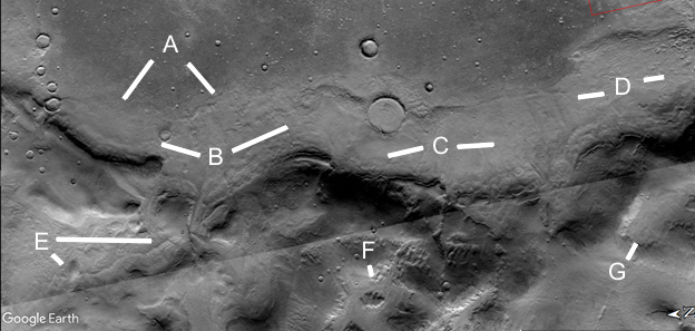
Hypothesis
This shows possible roads leading between hollow hills, it is logical that there would be movement between them. Sociologists and perhaps anthropologists may examine these routes to understand their use. It might for example be trade on the longer roads, movement to and from crops, etc. Some hills may be more important as communal meeting places, have government functions, house animals, be markets, etc. A shows something has worn the surface down to paler material, it looks like many lanes of a freeway. It may then indicate a lot of traffic, forming separate roads to avoid congestion. B shows a larger road shape going into smaller ones, it may also be the space between the roads has eroded making it look larger. E shows a hollow hill that has collapsed, there is a pale track from the roads at A and C to it. Roads appear in many routes to the right, a larger one at D. C shows a more separate road, it may be crops were planted in this direction.
Already the components of a possible civilization are starting to emerge. There are tubes connecting craters for water, hollow hills for dwellings, and roads between them. These represent a priori predictions, with more images the concepts of a civilization should be repeated to be real.

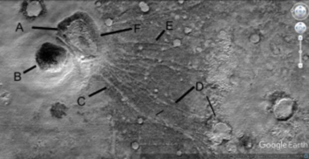
Hhh20
Hypothesis
The ejecta of this crater appears to be missing at B, the fragment at A ends on each side with flat ground. It should be impossible for ejecta to fly out of an impact crater and make such a pattern. Also the crater is not there, like it has been filled in. So there is no sign there the crater even existed to put out so much ejecta. C is a little more normal in shape for ejecta, D is mostly a gap not following the circular shape of a crater. E shows a hollow hill with bands on its roof, this could have been made from the ejecta as it would be loose material. F shows a straight edge of paler material around this hollow hill, forming a 5 sided straight shape around it like an irregular pentagon . G shows another hollow hill that has collapsed. Some of this may be finger ejecta as well to build dwellings.
Hhh21
Hypothesis
The two hollow hills appear to have merge together, A shows a wall like shape around the higher central core. B shows this wall has a smooth regular surface. C shows a possibly collapsed area, or where it has settled. D shows part of the wall around the second hill. E shows a collapsed or settled area. This is again surrounded by pale material, smooth compared to the rougher dark material around it. Hills should not attract this pale material, the hills may be constructed with the pale and dark material found around it.
Hhh22
Hypothesis
This shows the two kinds of hollow hill together. A is a lower flat hill with a dark surrounding wall and pale core. F shows the wall is even in width on its right side. B shows a dark hill with pale sides, it is unlikely it is buried by accident without burying the hill at A. C shows a road going to several craters and to the larger crater D at 5 o’clock. E shows another road, all of these appear to be preferentially seeking out the smaller craters. There should be no geological reason why these roads should be seeking out craters, if they were faults then they should only go through craters by chance. Also there would be no reason why they would radiate out of these hills. The idea of a civilization like this is not familiar to us, it may be these hills were a logical adaptation to protect against cold, predators, meteor impacts, radiation, etc. Sociologists and anthropologists then might consider how these formations connect to make a viable if unfamiliar habitat.
Hw23
Hypothesis
A shows how this tube has many bends in it, then disappears into the ground at 7 o’clock at B to reappear at 5 o’clock with B. It then proceeds with C, an S shaped reversal at 7 o’clock with D, then into the ground again at 5 o’clock with D. It then reappears at E, perhaps bifurcating into a broken tube at F. It is hard to explain geologically because where it is exposed it seems to follow a ravine. It would make sense if it was constructed in a ravine or it was dug to put the tube in. There may then be many underground areas that were habitats, we may only see the tip of the iceberg in these tubes and hollow hills.
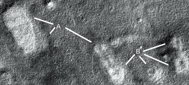
Hw23a
Hypothesis
This is a wider angle view, the area at the top of the image at A was probably the ocean. B, C, and D then may be a built up area like a shoreline some of which may be artificial. The tube then may have been a tunnel through this. E shows another tube connecting to a hill, F and G also may be hollow hill formations.
Hw23b
Hypothesis
This was shown as E in the previous image Hw23a, A here shows a small triangular hill with a tube coming out of it to the right. B at 10 and 2 o’clock shows this tube in a kind of sinusoidal pattern, C at 9 o’clock shows some bumps along it as it perhaps degrades. At 3 o’clock and 12 o’clock C shows another possible tube going up into another small hill. B at 4 o’clock may show a hollow area underneath this. The tube construction technique is not clear, some have these bumps perhaps like internal supports. Other show collapses and a darker interior in shadows. Often the sides appear to be flat rather than curved, going up to a peak. Some sections appear to have disconnected and rolled along the ground as will be shown, indicating a rounded shape.
Hw24
Hypothesis
A, C, and D are unusual hill shapes, A has many bands of darker shades. C appears to have a wavy ridge going through its roof. D may have a dark patch. E is similar, the problem with many of these hills are they are so low, wide and rounded like an irregular dome. Architects might consider this, whether the dome shapes are regular enough to be strong. E has two small craters on its roof, if this is artificial then it was strong enough to withstand these or it was patched. B shows a raised edge, the shadows imply there could be an entrance here. F shows a ridge which may have been an interior support for a collapsed dome, G shows the edge of an adjacent hill. The internal support then is a possible construction technique as is the low dome shape.
This is an example of a wide low dome, some of these have step like arcs around the sides as if built up in bricks. If they top of the hills is rounded it acts more like an arch and is stronger.
Hr25
Hypothesis
Some roads appear to be short, between hills and craters. Other extend for long distances, hundreds of kilometers. They do not seem to be faults or dust devil tracks as close ups will show later. A fault should not meander like this, also there is no sign of river banks so they are not formed by water. A shows a road from a hollow hill to a crater, this has a lighter area around it which is perhaps cleared or from traffic. B shows how the road appears out of the other side of the crater. Each side tends to go into the middle of the crater bisecting it, this is typical when road and tube shapes go to craters. Random crater impacts on these should intersect them at all different point but they are usually tangents or bisections. C shows how the road meanders perhaps from small obstacles on the ground when constructed, D shows it ends in a field of small craters, perhaps used for fishing or collecting water. The road then has a logical purpose here, associated with water. The construction technique may be to clear away darker rocks exposing a smoother lighter soil underneath. Other roads appear to show soil has been added to the area as they are raised above the terrain.
Hr26
Hypothesis
This shows the road extending to the right past the craters in Hr25, C shows a small road going downwards D shows how these craters are surrounded by lighter soil perhaps from traffic. A shows the road going into a hill at B, then extending to two other hills to its right. Roads appear to be aimed at craters and hills, they rarely go past them without some kind of connection. Geologists might consider how a road, if formed naturally, seems to prefer craters which should have random location and these hills.