Martian Hypotheses Book 10
Preface
This preface refers to twelve new books of Martian anomalies. Each book is approximately 250-270 pages in length, they also have the same introduction which is about 70 pages long. There are about ten more books partially completed to be published, the books cover anomalies all over Mars and have about 3000 images in total. If you like these books, and would like to support this work, then you can buy the books on Amazon. You can search for “Greg Orme” and “Martian Hypotheses” there. You can also support this work at Patreon at this link: https://www.patreon.com/ultor. If you enjoy the books you can also help with reviewing them at Amazon.
The aim is to raise money with these books to fund an institute to study these formations. If these are artificial then they will need to be studied by scientists from many fields such as biology (examining the faces, their bodies, and fish sculptures), geology (analysing the materials used in their construction), anthropology (why repeated faces with crowns were constructed, perhaps gods or rulers), mathematics (for geometric formations), sociology (how these societies worked), economists (working out how the society functioned, for example with farming, fishing, working together for large scale constructions), engineering (how these formations were constructed), and archaeology (examining ruins). How this would be done is not clear, but this institute would try to make a start on understanding these formations. No one really knows how to study an extinct alien civilization, if this is one. Most likely, if they are real, then a more professional organization would take over this work later. The intention then is to bridge the gap between amateur analysis of these formation to a much better funded organization, perhaps at the government level. The evidence gives a reasonable case for artificiality, but much study needs to be done to determine how plausible this is.
The introduction is repeated at the start of each book. If you have read it you might skip forward to the new images. However it may be valuable to read it more than once, to see how the images you see are connecting into these classifications. Often the images have a lot of details, each time they are examined more of these can be seen. They might also inspire you to see other connections, for example one image might be similar to another in a different part of Mars. This is likely to happen, even with so many images the surface of this hypothesis is barely being scratched. Mars has an area similar to the land area of Earth, this is because much of Earth is covered in oceans. For this much land then 3000 images is likely to have missed many important discoveries.
You can also use the indexes in each book, they refer to many similar formations throughout them. For example, if you are looking at hypothetical road formations then roads in many different areas can be found in the indexes. It would be possible then to quickly see all the different kinds of hypothetical roads in all 10 books. The idea behind the introduction is to give an outline to the global hypothesis, how these different formations connect together into a hypothetical Martian civilization. It’s important then to get an intuition of how these formations connect together globally.
Some areas for example might have hypothetical roads for transport, other might have hypothetical tubes like a covered road. Different terrain, available materials, and climate might have led to one being used over the other. It may be as Mars cooled it became necessary to travel under cover because of the cold. Another possibility is predators or meteors made traveling on roads too dangerous. Also there are many hypothetical dam formations, but the construction techniques vary between areas. Some are formed with dam walls attached to the crater, when they break some show a cavity under them and others do not. This would indicate the dam wall was dug into this cavity to keep it from sliding down the crater wall. In other areas this was not necessary, it may be that there the crater wall was harder rock which the dam wall could be cemented to. Some show columns and layers in them but others have evenly spaced vertical grooves on the dam walls. Some dams are excavated out of the crater wall or the material at the bottom of the crater, these may depend on the rock type in the crater. For example, if the crater wall is too easily broken then an excavated dam might have been the best engineering solution.
Some areas have hollow hills, these are where a hollow habitat may have been built on an existing hill or the whole hill was constructed. In some areas these have layers similar to a Cobler Dome, this is where bricks form the dome in decreasing circles as the dome is built up. These are called amphitheatres as a friendly name, the first amphitheatre formation looked more like seating around an amphitheatre. Other hypothetical buildings have no layers in their roofs. This may have depended on the materials available. Many appear to have a smooth skin like cement which has broken up in some parts of the roof, and is intact in others. In many areas this is more intact on the southern side, as the skin breaks off the softer inner parts of the roof appear to have eroded faster and collapse. The one sided erosion may imply a prevailing wind, or as the oceans and air froze at the pole this created the erosion.
There are also large areas of walls and room like shapes, these are hypothetical cities. Other areas connect these hollow hills together with tubes or roads as another kind of hypothetical city. Still others seem to be made of tubes that connect together in intersections called a tube nexus. This may have been because of the climate further from the equator, for example tubes might have been used to travel through in colder areas.
The Martian Faces are mainly discussed in books 11 and 12, a reprint of published peer reviewed papers. These differ according to where they are. The Cydonia Face, Nefertiti, and King Face all fall on a great circle, this is hypothesized to have been an old equator that lines up with a known previous pole position west of Hellas Crater. The newly discovered Queen Face is in Cydonia but not near the old equator. If the faces were used to mark latitudes and longitudes then the overall system remains obscure. For example there is a large hyperbola shown close to the old equator. Another is far from this equator, but drawing a line from it to Nefertiti gives a right angle to this old equator. Joining these two hyperbolas and the King Face gives an Isosceles Triangle. The hypothesis of these mapping system is highly speculative at this stage.
Canals, lakes, and water channels also vary in different areas. West of Cydonia there is an extensive array of hypothetical canals, also east and west of Elysium Mons. Some of these connect to larger lakes which may be artificial. Some hypothetical dams have water channels to direct water into a dam, and to collect an overflow to another dam.
There are also darker areas often bounded by walls or geometric shapes. These may have been farms, why they appear in some areas like around Cydonia and in Isidis remains unanswered. Other areas contain hypothetical artefacts but no farm formations, so these creatures would have used a different way of collecting food.
The idea of these books then is not just to prove artificiality, but to try to prove a global hypothesis of how the whole civilization functioned. Once the evidence becomes plausible enough, and the shock wears off, this larger question is much more interesting. Each section is labelled with the title hypothesis to make clear these notions are being proposed along with the evidence there. The sections all have many keywords connecting to the index. If you see a connection to a kind of formation then it is easy to find similar formations. In seeing the global hypothesis the different pieces of the puzzle are more likely to come together, for example the hypothesis of dams sounds less plausible if it is not connected to the hypothesis of buildings and farms. Together they give the ideas of habitation, food, and water. The conclusions can be controversial. However there is so much evidence it was better to put it all together into a more comprehensive hypothesis. Otherwise people are looking at isolated formations like faces without seeing the overall context in which they appear.
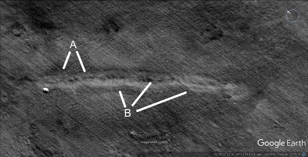
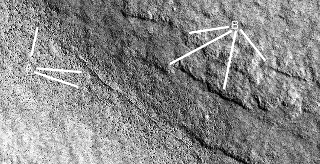
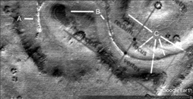
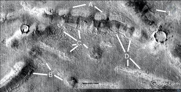
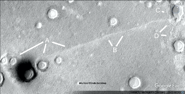
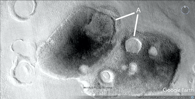
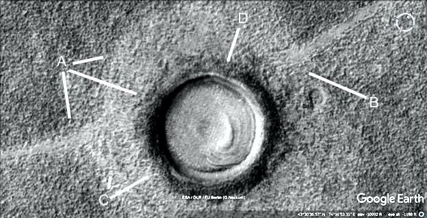
Cymhh473j
Hypothesis
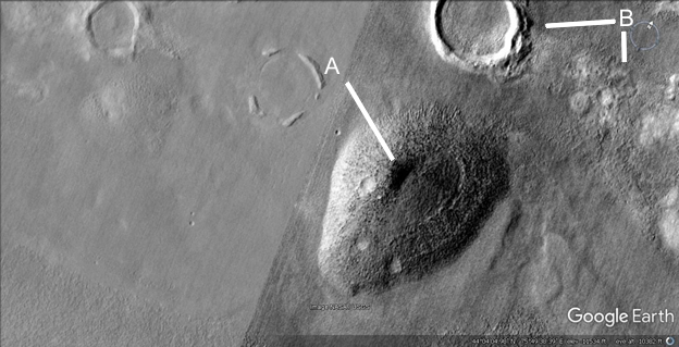
A and B shows walls in a triangle.
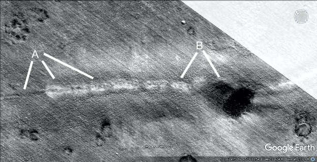
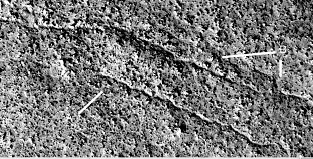
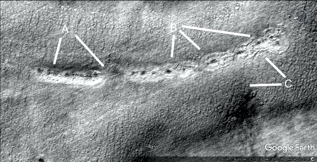
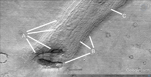
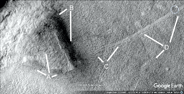
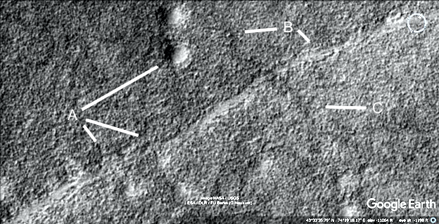
Cymhh473k
Hypothesis
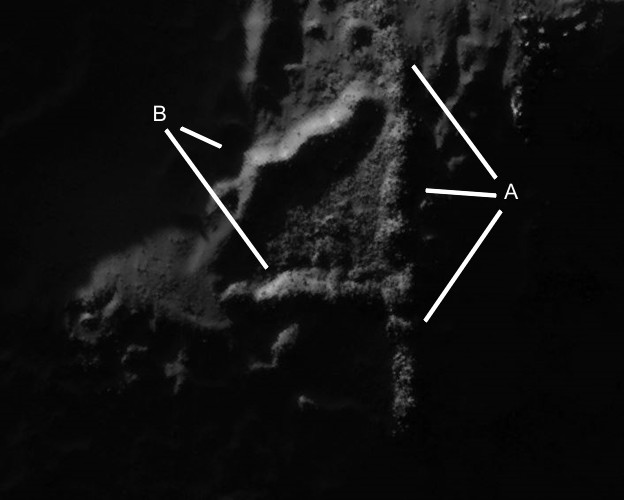
A shows a road or collapsed tube, this continue soon to C at 6 o’clock. From 2 o’clock a road goes up to B connecting to several hollow hills. D and E show more tubes connecting to a hill.
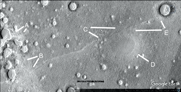
The next section analyzes an area called Protonilus
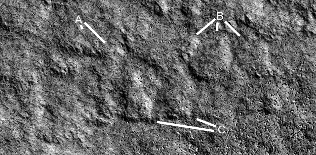
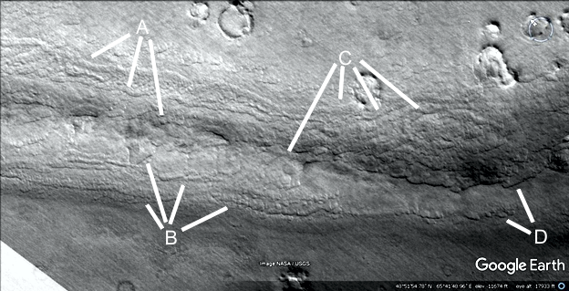
Prca475
Hypothesis
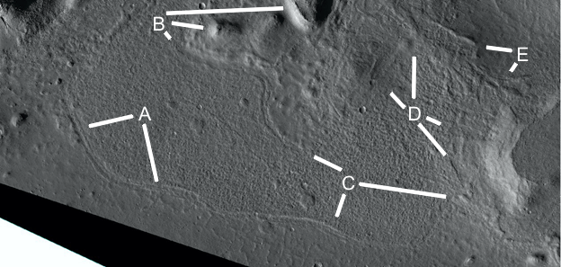
These water channels have a ridge going down the middle. A shows some unusual dark spots perhaps related to habitats. B shows show this side of the channel is quite even as does C. Other areas have had a tube inside a channel like this, in several areas the insides were exposed.
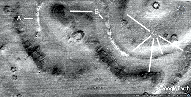
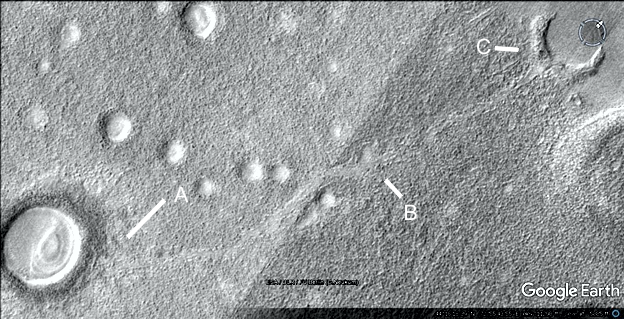
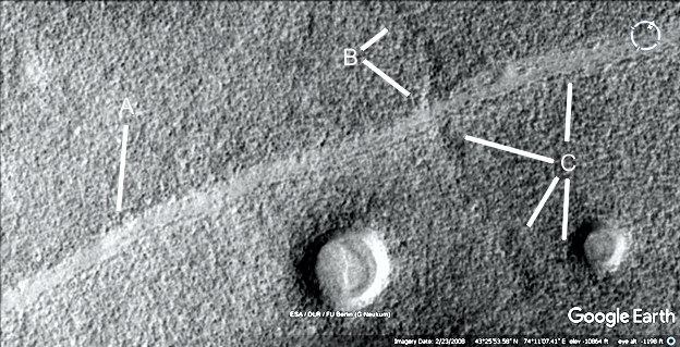
Prca477
Hypothesis
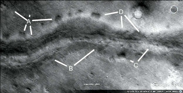
A related ridge or tube in this area, it may go down into the ground on both sides. A and B show dark spots like the roof is collapsed. B at 2 o’clock looks hollow in the center.
Prca478
Hypothesis
Another one of these tube shapes, A at 7 o’clock shows where it disappears leaving a groove. This groove then extends into the tube shape at 4 and 5 o’clock, it also seems to have broken into sections. The groove is problematic because it would have to form in the tube shape as well as in the bare ground, but this would be a different geological process.
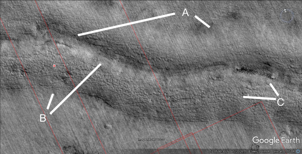
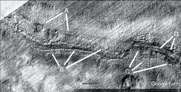
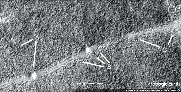
Prca479
Hypothesis
This shows another tube in a channel, or perhaps it was buried and has been exhumed. A at 8 o’clock looks collapsed in the center as if hollow. At 4 o’clock the banks of the channel is shown, the bottom of this channel has an unusual texture as seen at C at 9 o’clock. B at 1 o’clock sows the other edge of the channel bank, at 1 o’clock there appears to be regular sections of the tube shape like arches inside it. This is seen in other tubes and may be a construction technique.
Prca479a
Hypothesis
This is a closeup of one of these channels, the texture is regular like it is made of bricks. Particularly at A at 4 o’clock there seems to be brick like shapes about the same size. At 1 o’clock the tube shape in the middle of the channel is shown. The two edges are all that is left. B shows another hollow section of this, C at 7 o’clock shows a hollow where the tube would be and at 4 o’clock it is much higher. D shows how there are layers on the sides of it.
Prca479b
Hypothesis
Another part of this water channel, the central tube shape has a crack along it at A. B shows more of these layers along its side. This can be a construction technique, to make layers of cement in the base.
Prca479c
Hypothesis
Some tubes are shown here, these seem to go across uneven and eroded ground but are in much better condition like cement. B at 6 o’clock shows a fork into two tubes.
Prca479d
Hypothesis
A closeup of brick like shapes in the channel, each piece is around the same size and joins together with the others. A water channel should have eroded the rock not broken it up into brick or tile shapes like this.
Hypothesis
More of these tube shapes, A shows dark spots along it like it is breaking up. B at 9 o’clock is like a hollow hill as seen in many other areas, the dark patch on top may be the roof. B at 5 o’clock shows more collapsed areas. C at 7 o’clock shows the bank is well defined, at 4 and 8 o’clock the tube shape changes from dark to pale. At 10 and 4 o’clock the bank is also well defined.
Prca480a
Hypothesis
This part of the tube shape is a near perfect parabola as shown, unlikely to occur by chance. The tube shape is also about the same height and width wherever seen, it does not vary much randomly like a natural formation from weather erosion.
Prca481
Hypothesis
This part of the water channel was transverse stripes or grooves like the bricks are arranged this way. These stripes are all about the same width, not varying randomly, and about the same height. They have eroded evenly rather than developing pits in the surface. The central tube shape appears to be breaking up into these dark spots exposing a hollow interior. Between A there is a dark groove along it as if hollow, at 4 o’clock it seems to be broken. B shows pieces like small hills connected together perhaps as a construction technique. C shows some of these stripes, they pass right under the central tube shape, this can be seen by following the lines on both sides. It means then that the central tube shape had to come later and was added on top of the stripes. This would be hard to explain geologically, how this tube could form on top of the stripes without affecting any of them. Also if the stripes were cracks then the central tube shape should change their course.
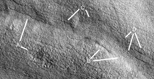
Prca483
Hypothesis
This shows another water channel, the tube shape at A is much more eroded with an intact piece at 8 o’clock, and a collapsed section at 6 o’clock. B appears to be the lower edge of the former tube exposing a hollow or groove that was in it. C shows a section where this groove is covered over, the angular sections are like bricks. D also shows a groove like bricks.
Prca485
Hypothesis
The crater ejecta has an unusual shape, the water channel is regular in size at 6 and 7 o’clock. The edge of the ejecta at 4 and 5 o’clock is nearly a straight line and steep rather than randomly shaped. This ejecta if anything should be more spread out in the channel from erosion. B and E also show unusual shapes in the ejecta, it may have been built up into a hollow hill. C and D also show a regular shaped water channel but with an unusual ejecta shape going into it.
Prca487
Hypothesis
More tube shapes are shown, at A they have broken up into sections with a line of dark soil under them in the image. B shows similar related shapes, at 9 o’clock this is larger and a hollow hill shape with patches on the roof is at 4 o’clock. At 10 o’clock there may have been a tube eroded away. C shows another tube not in a water channel at 7 o’clock, it goes into the larger tube shape on the left. At 8, 10, and 12 o’clock there are more layers, at 5 o’clock it looks like a degraded hollow hill. D shows another tube shape with a hollow interior at 4 and 6 o’clock, more layers at 11 and 1 o’clock. E appears to be another layer, much smoother on top.
Prca488
Hypothesis
This water channel ends suddenly, this makes it less likely to be natural as water would not stop like this after eroding the channel. A shows layers along the side of the channel at 1 and 2 o’clock, at 3 and 5 o’clock there appears to be a hollow hill. B shows more of these layers running along the channel, the dark material at 8 o’clock is like the roof seen on many hollow hills. C shows more of these layers.
Prca489
Hypothesis
These layers are found along many of these water channels, A shows they go up to the sides connecting to the more natural looking ground. At 5 o’clock there may be the remains of the central tube shape, also seen a B at 11 o’clock. C shows more layers and the continuation of this tube shape at 7 o’clock, D shows more layers. The construction technique would be to make a higher layer on the side of the bank, then another overlapping further down like fish scales. This would allow a layer to dry before the next one was adhered to it. It would also allow a frame to hold the layer of cement in place while it dried.
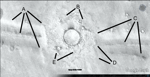
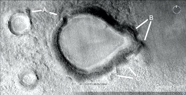
Prhh492
Hypothesis
A at 12 o’clock shows a hollow hill connected to a crater, though the impact should be random the hill seems to open up and go around the crater rim like it was known to be there. This happens in nearly every example of a hilled crater, thousands of them. At 1 o’clock there may be a collapsed area, at 2 o’clock the hill smoothly joins to the crater rim with dark material in both of them. A at 4 o’clock shows patches on the roof of another hollow hill, perhaps other craters like the two shown were repaired. B shows fine tube shapes at 4 and 6 o’clock, also a hill surrounding this crater from the left at 1 o’clock. C shows a small tube into a crater at 10 o’clock and a notch in the crater rim at 2 o’clock. D shows a smooth artificial looking hill at 8 o’clock, then a smooth area around it like cement at 9 o’clock, above this at 10 o’clock the ground looks like many tubes are under this smooth skin. E shows more tubes going into the hill.
Hypothesis
This is a road shape going from the hollow hill at A along B into the crater at C. This crater is then connected to another, shown by D perhaps by a hollow hill.
Prr494
Hypothesis
This shows another road shape, A points to many pits not like typical crater shapes. They may have been altered and connected to make bigger dams. B shows a smooth area around these at 8 o’clock, then a road or tube at 7 o’clock which has forked into others of these. C shows how this road connects into the side of the hill at D, it seems to go inside the edge of it leaving a groove then continue on through E to the crater at 11 o’clock.
Prr495
Hypothesis
This shows another road connecting craters from A through B to C, its surface is much smoother than the surrounding terrain.
Prc496
Hypothesis
The crater at A at 9 o’clock has a small hill connected to the crater rim, similar to the one at 4 o’clock perhaps for access to the water that was inside it. B shows how this crater has a very unnatural protrusion as if altered. At C the rim seems to extend outwards at 11 o’clock and into a tube like shape at 10 o’clock.
Prhh497
Hypothesis
A shows how these two hollow hills are collapsed, at 8 o’clock only the outer wall is left. The craters like at 7 o’clock may have darker repaired areas around them.
Hypothesis
The hollow hill has collapsed at A, B shows a straight wall still standing. C shows another road going into the hill perhaps with two lanes, this extends to D at 10 and 1 o’clock. There may be another road at 7 o’clock.
Prr499
Hypothesis
This is a closeup of a road, much smoother than the surrounding terrain like cement. It extends past A to B where a tube or raised road intersects it. C shows this tube going down from 10 o’clock, then possibly at 6 and 7 o’clock into the crater.
Prr500
Hypothesis
Another road section is shown, A shows a smaller road or collapsed tube at 8 o’clock which appears to be directed at the small hill at 6 o’clock. Another hill like this is at B at 10 o’clock, there is a smoother flatter area around this from 9 to 11 o’clock. C shows a continuation of the road, the shadows indicate it is perhaps lower than the surrounding terrain.
Prr501
Hypothesis
A shows the same road going into a crater, it appears to be built up like a hollow hill around the crater rim. This pale material is different from the darker rim, so it could not be ejecta. B shows how the road goes over an into this pale material like cement, so it could not have been a preexisting road hit by a crater. The road had to have been formed after the crater was. C shows how this pale material goes up to and covers part of the darker crater rim, this again means it had to come after the crater and so it moved upwards onto the rim against gravity. Around D this pale material is smoother so it may be cement like the road material. It’s unlikely any other kind of material would have lasted so long.
Prr502
Hypothesis
This part of the road appears to be more eroded at 4 and 5 o’clock, the crater at 2 o’clock may have this road material covering it like a dam. B shows a possible tube or second road at 9 o’clock going down to C, at 4 o’clock B shows a more intact piece of the road that seems to have broken off from both sides.
Prhh503
Hypothesis
A shows another hollow hill, the outside is in good condition but the center appears to be collapsed. It may also be like a walled hill where sometimes the roof sinks lower like a catenary shape. B shows a connection from the crater at 9 o’clock, this is unlikely to occur with a chance impact as it seems to widen out to meet the crater rim.